Large hail, damaging winds threaten North Texas as storm chances increase

Storm chances return Tuesday evening, mainly across our far western counties, where a few storms could become strong to severe with hail and gusty winds.
A conditional severe setup continues Wednesday, with scattered storms developing mainly in the afternoon and evening, especially near the Red River and western North Texas.
A strong cold front arrives Saturday, bringing a sharp cooldown and drier air to finish the weekend.
Tuesday evening and overnight
Warm and humid conditions remain in place across North Texas as southerly flow continues to pull in Gulf moisture, keeping us in an open warm sector. Storms will develop well to our west along the dryline, where the atmosphere is more favorable for stronger storms. As these storms move east, they will begin to lose intensity, running into a more stable environment and a lingering cap across North Texas.
Even so, a few clusters could hold together long enough to reach our northwest counties, bringing wind gusts up to 60 mph and hail up to half-dollar size.
Storms will likely transition into weaker clusters as they approach the I-35 corridor, with activity becoming more scattered across the metroplex overnight. After midnight, expect mainly weakening showers.
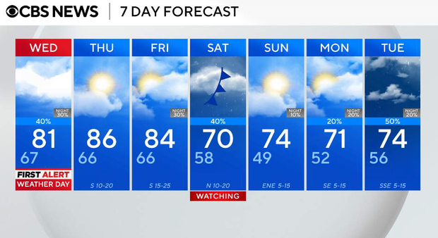
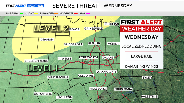
Wednesday is a First Alert Weather Day
We remain in a warm, humid, and somewhat capped environment, but with slightly better forcing and a dryline edging closer to North Texas. There may be a few elevated showers or storms in the morning, but the better window comes later in the day. By the afternoon and evening, scattered storms are expected to develop, with the highest coverage and strongest storms likely northwest of DFW and near the Red River.
A few storms could become strong to severe, producing gusty winds and large hail; however, this remains a conditional setup. Storm coverage and intensity will depend on how much the atmosphere can destabilize, especially if cloud cover breaks enough to weaken the cap. Overall, severe weather will be isolated, not widespread.
Thursday and Friday will be dry
A subtle ridge builds overhead, which will suppress storm development despite continued moisture in place.
That means dry conditions on both Thursday and Friday.
Temperatures will be warmer, with highs climbing into the upper 80s on Thursday and remaining warm on Friday. There will be continued humidity, but very limited rain chances
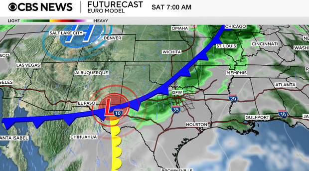
Saturday, a cold front arrives
A strong cold front for this time of year moves through North Texas. This front will bring a quick round of showers and a few storms. We expect generally light rainfall totals (most under 0.25") due to fast-moving precipitation. Behind the front, you can expect breezy north winds and a noticeable drop in temperatures. Highs fall from the upper 80s late week to the upper 60s to low 70s this weekend.
Sunday and early next week
Cooler, more stable air settles in behind the front. Sunday looks cooler and drier with highs in the 70s. A reinforcing high keeps temperatures below normal early next week. Southerly flow gradually returns by Tuesday, bringing temperatures back closer to seasonal averages.