Rain continues Wednesday morning across North Texas as wind gusts increase


After a very active evening Tuesday across North Texas, showers will continue in waves through early Wednesday morning, and during parts of the morning commute.
This will bring an elevated flood threat to portions of North Texas during those Wednesday morning hours, as repeated rain falls over saturated soil.
A flash flood warning was issued for Tarrant, Denton, Dallas and Collin counties until 3 a.m.
Rain continues in waves early Wednesday morning before storms exit
Rain continues in waves early Wednesday morning, bringing an elevated flood threat to the area. Showers start to move east by about mid-morning, with a severe storm threat for our far east-southeast counties lingering into Wednesday afternoon.
Watch for threats of flooding during the morning drive and also for any debris in the roadways following very strong wind gusts that moved through the area Tuesday night, especially west of the 35 corridor.
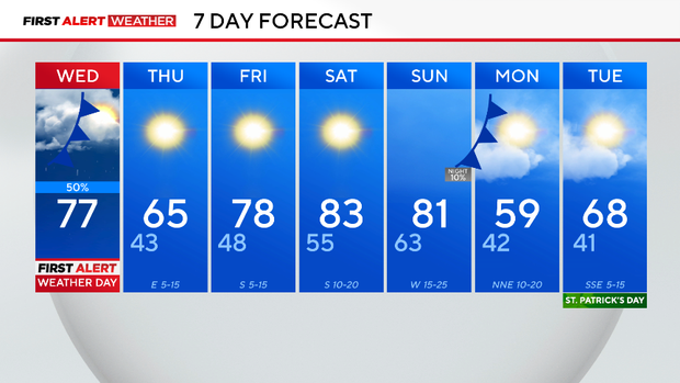
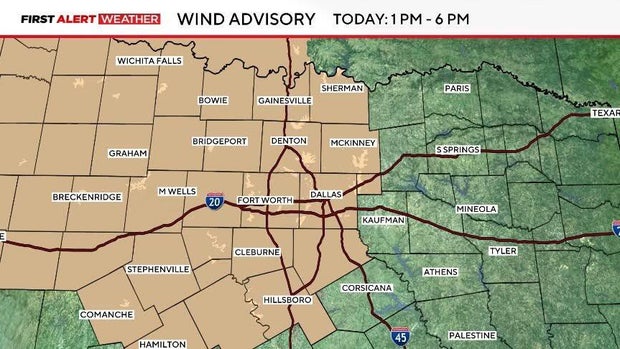
Temperature-wise, the morning will be mild in the 60s, warming to temperatures near 70 by lunch and a high in the upper 70s by the late afternoon. A wind advisory is in effect from 1 to 6 p.m. Winds will come from the south 20-30 mph, even gusting up to 40 mph at times.
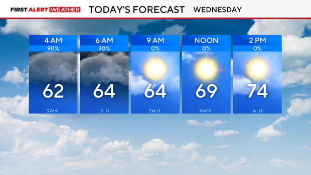
Shortly after the morning commute, showers look to push to our east and southeast, which is where our severe weather threat lies Wednesday afternoon.
East Texas has the highest potential of severe weather, with the Storm Prediction Center highlighting a level 2 out of 5 risk.

The cold front ushers in a cooler and drier airmass as well as a shift in the wind, leaving North Texas with a much calmer weather pattern for at least the next week. A very pleasant and warm weekend is ahead.
The next cold front arrives Sunday, but it looks like a mainly dry front. It will bring very gusty winds to the region, and leads to a steep temperature drop from Sunday into Monday.