Chicago First Alert Weather: One more day in the 90s
One more day with highs in the 90s before temperatures cool off.
Watch CBS News
Laura Bannon is the weekday morning meteorologist. A native of Chicagoland, Laura grew up in Naperville. She is an Emmy-nominated meteorologist and holds her NWA Seal of Approval.
Upon graduating Neuqua Valley High, Laura attended the University of Missouri. While completing a degree in communication at Mizzou, Laura attended Mississippi State University distance program and obtained a Bachelors of Science in Geosciences.
In college, Laura landed her first on air job in Jefferson City, Missouri. Laura worked weekends at KRCG her senior year and secured her first full time broadcasting job at WBBJ in Jackson, Tennessee. From there, Laura went on to serve on weather teams in Wichita, Kansas; Dallas; Nashville; and currently Chicago, experiencing a variety of severe weather markets across the country.
Laura has covered many severe weather outbreaks. One weather event she'll never forget is the 2020 Nashville tornado. Laura was the meteorologist on duty when an EF-3 tornado ripped through downtown Nashville, killing 24 people. Laura and her team were nominated for a 2020 Emmy in the Breaking News category for their extensive coverage.
Along with the weather, one of Laura's passions is helping others with disabilities. In each of her residencies, she has volunteered at therapeutic horseback riding centers. An equestrian since a young girl, Laura uses her knowledge to assist children with physical, emotional, and behavioral disabilities learn how to ride horses. She has found it to be a life-changing experience working one on one with these children and watching their progress week after week.
After work, Laura enjoys working out, going to the gym daily, training for Cross Fit events and taking long walks outside.
One more day with highs in the 90s before temperatures cool off.
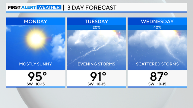
Temperatures will be in the mid-90s with feels-like temperatures near 100 degrees.
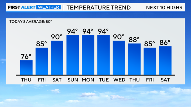
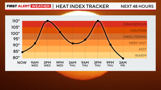
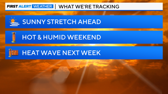
Friday will be warmer with temperatures in the mid-80s before climbing to the 90s for the holiday weekend.
Temps reach the 70s again ahead of a heat wave.
A beach hazard statement will remain in place through early Thursday morning.
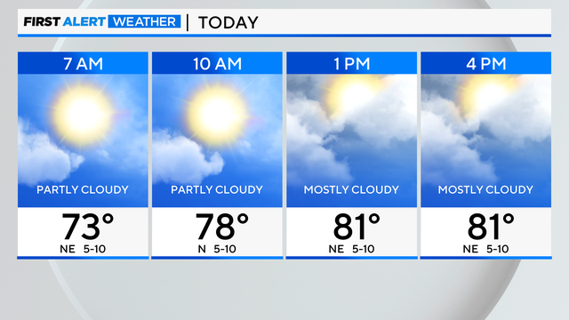
After a sunny and pleasant morning, clouds increase and temperatures climb to the 80s.
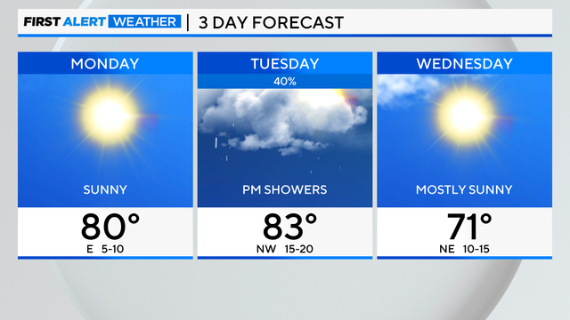
A slight warmup will bring temperatures back to the 80s Monday and Tuesday.
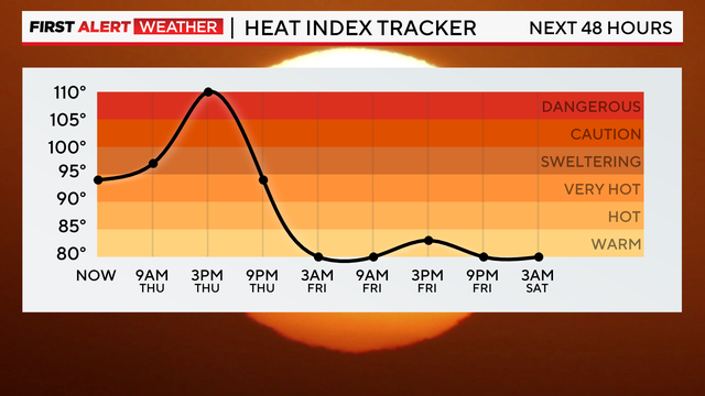
The heat wave is finally over.
The Excessive Heat Warning remains in effect through 8 p.m.
An Excessive Heat Warning takes effect from 11 a.m. through 8 p.m.
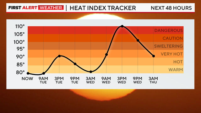
Tuesday's temperatures will be in the low 90s and feels-like temperatures will be near 100 degrees.
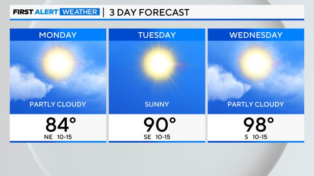
Monday's temperatures will be in the 80s. Highs Tuesday reach the 90s with feels-like temperatures at or above 100 degrees. The extreme heat is expected to continue through Friday.
Humidity levels will remain low in the meantime with highs in the lower 80s.
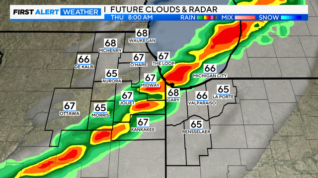
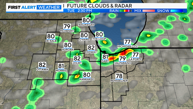
Showers and thunderstorms move into the area Thursday morning.
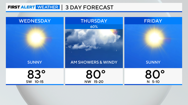
Wednesday's temperatures will be in the 80s with sunny skies.