Rain in Denver, accumulating snow in the mountains

A spring storm is bringing a soggy and cool start to the week across Colorado, with rain for the lower elevations and accumulating snow in the mountains and upper foothills.
Many areas along the Front Range have already picked up around 0.20 to 0.40 inches of rain, with more moisture expected through the day on Monday. Another round of precipitation is likely late Tuesday into Tuesday night before the system slowly moves out.
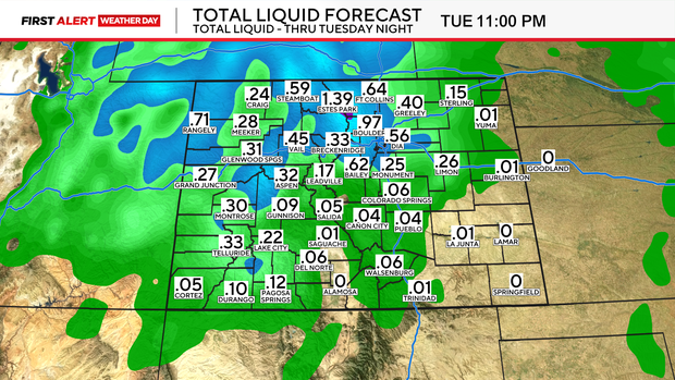
Denver, Boulder, Fort Collins, and much of the lower I-25 corridor will stay mainly rainy. A few wet snowflakes may mix in at times, especially during heavier showers, but little to no accumulation is expected for the lower elevations.
The bigger winter impact will be in the mountains and upper foothills. Winter Storm Warnings and Winter Weather Advisories continue through 9 p.m. Monday for parts of the northern mountains, North Park, and the northern Front Range foothills.
The highest snow totals are expected near Rocky Mountain National Park, where 8 to 18 inches of snow is possible. Many mountain areas north of I-70 could see 4 to 10 inches of snow.
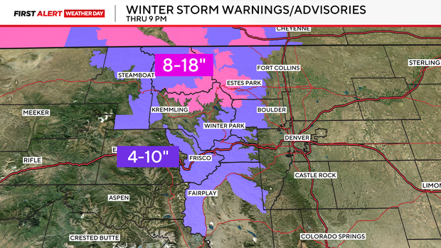
Travel could become slick in the high country, especially during heavier bursts of snow.
Behind the storm, colder air could bring one more spring freeze Monday night into Tuesday morning. A Freeze Watch is in effect for parts of the plains, where temperatures may drop as low as 28 to 30 degrees. Sensitive plants and early-season vegetation could be damaged.


