Severe storms could bring 70 mph winds and flash flooding to eastern Colorado Tuesday

Severe thunderstorms could bring damaging wind, hail, and flash flooding to parts of eastern Colorado on Tuesday afternoon and evening.
A Severe Thunderstorm Watch is in effect through 8 p.m. Tuesday for portions of the eastern Denver metro area and eastern plains. The strongest storms could produce wind gusts up to 70 mph and isolated hail up to 1.5 inches in diameter. A ground delay will be in place for Denver International Airport throughout the evening due to the thunderstorms moving through.
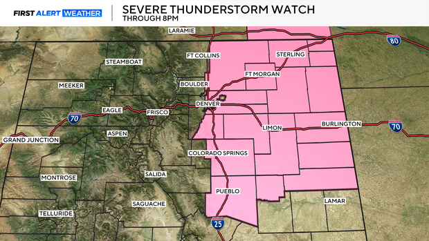
The greatest severe-weather threat is east of Interstate 25, especially across eastern and northeastern Colorado. Denver and the I-25 corridor could still see thunderstorms and strong outflow winds, but storms will be more isolated.
Flash flooding may become just as significant as the severe-weather threat.
A Flood Watch is in effect from 3 to 10 p.m. Tuesday for Logan, Washington, Morgan, and Lincoln counties, along with eastern portions of Weld, Adams, Arapahoe, and Elbert counties.
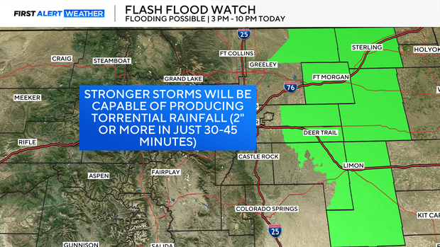
The strongest thunderstorms could produce more than 2 inches of rain in only 30 to 45 minutes. Some weather models show an isolated 3 to 5 inches of rain in Washington County, but that is not expected across the entire county.
Heavy rain is also possible in the mountains and foothills. Recent burn scars will be especially vulnerable to flash flooding and debris flows.
Another round of thunderstorms and locally heavy rain is possible on Wednesday before Colorado begins drying out later in the week. Hotter temperatures are expected to return by the weekend.


