Pittsburgh's storm wasn't technically a "derecho." Here's why.


A damaging line and complex of storms moved through Western Pennsylvania around 5 p.m. on Tuesday, hitting the heart of the Pittsburgh metro before racing into Westmoreland, Armstrong, Indiana and Cambria counties before eventually dying out east of State College.
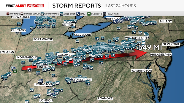
The storm complex originated south of St. Louis, Missouri, just after 7 a.m. and continued moving northeast through Illinois, Indiana and Ohio before arriving in western Pennsylvania just after 5 p.m. At least three people have died, and at one point, about 400,000 people were without power.
The technical name for such a long-lived storm complex in meteorology is called a "mesoscale convective system," or "MCS."
What is a derecho?
There are certain classifications of MCSs called "derechos," which can be named after the storm if all of the criteria are met. Those criteria are: a swath of damage extending at least 400 miles; wind gusts to 58 mph along most of its length; several well-separated gusts of 75 mph or greater; and radar signatures of a bow echo and rear inflow jet.
The storm complex that came through the Pittsburgh area on Tuesday met three out of four criteria, but at the moment is not technically a derecho. There were no official 75 mph winds or higher along the early path of this line of storms when it was moving through Indiana and Ohio. KDKA-TV's meteorologists will be monitoring in case any new data arrives.
Storm produces incredibly strong wind gusts
Despite this, the storms produced a 71 mph gust at Pittsburgh International Airport and a 79 mph gust at Latrobe. Gusts over 60 mph were observed all the way to Altoona. The 71 mph gust at Pittsburgh International Airport is the third highest behind a 75 mph gust on April 8, 2020 and an 83 mph gust on July 10, 1992.
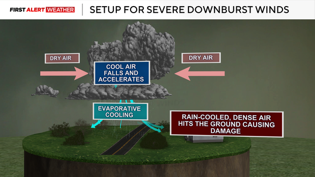
Tuesday's storms were able to produce intense damaging downburst winds because of a dry layer of air in the mid-levels of the atmosphere and below the cloud bases. The clouds that form are able to entrain that dry air. The dry air is then cooled by precipitation evaporating into it, causing a dense and heavy burst of wind to rush down to the surface.
If the air is relatively dry beneath the cloud bases, then that downward rush of wind can accelerate before it hits the surface, spreading out and causing widespread damage. Think of this as dropping a water balloon and the balloon splatting out on the ground.
NWS Pittsburgh surveys damage, estimates 95 mph winds
While the storm may have only lasted for a few minutes, it left worth of cleanup and recovery. The National Weather Service looked at damage in Wilkinsburg, Squirrel Hill and neighboring communities. Trees blocked the streets, landed on roofs and crushed cars. Power lines were sprawled, and some streetlights were crushed under Mother Nature's power.
"It basically was a wall of wind that happened instantly," Chris Leonardi with the NWS in Pittsburgh said.
According to him, it was a squall line of straight-line winds that left the destruction.
He said when the storm entered the Pittsburgh area, it grew stronger, causing the widespread destruction. Surveyors determined the cause by looking at the pattern in which trees and power lines fell, along with how widespread the damage was.
Leonardi said it "didn't indicate any rotation, but instead a straight-line damage pattern."
Nevertheless, there were winds upwards of 95 mph. Leonardi said this storm shows why severe thunderstorm warnings should be taken seriously.
"If we thought this was a tornado, this damage, some of it was equivalent to an EF-1 tornado," Leonardi said.
"To see this kind of widespread devastation in the Pittsburgh area and surrounding area, with such widespread damage is unusual," he added.
The last time he could think of an incident like this would have been when straight line winds tore through eastern Ohio, the edge of the local NWS coverage area, in June of 2020.
Another rarity is the use of the destructive tag in a severe thunderstorm alert.
"We saw early on that this was a very unusual, very destructive event, and that's why we went to that high a level, so people knew ahead of time," Leonardi said.
He said this serves as a reminder that all severe thunderstorm warnings should be taken seriously, and recommendations should be followed.


