Gusty winds possible again and large hail as another round of storms moves through, First Alert Weather Day issued

More storms could be moving through the Pittsburgh area again this afternoon.
First Alert Weather Day
There is a perfect setup for large hail and gusty winds for the afternoon, First Alert Meteorologist Ron Smiley says.
Storms will be moving backwards, coming in from the southeast and moving northwest. Storm timing is faster than originally expected and will help to fuel the stronger storms, Smiley said.
Storms could move in as soon as 1 p.m. and continue with at least two rounds through 9 p.m.
Daily Forecast from the KDKA Weather Center
The sunshine has added more fuel to the atmosphere today, triggering some severe thunderstorm warnings southeast. That's where our system is coming from.
Sunset Tonight: 8:21 p.m.
Average High: 69 | Low: 47
They will be scattered throughout the afternoon and evening, starting east, but the biggest threat will be heavy downpours for areas that picked up around two inches of rain yesterday, and then large hail and damaging winds.
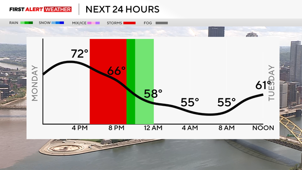
Rain continues overnight before we get dry time tomorrow. It's going to cool down significantly on Tuesday with more widespread rain Tuesday evening. The threat of severe weather tomorrow is low, and just a general thunderstorm is expected.

Wednesday, we are back in the 70s after a spotty morning shower. Thursday, it cools down again to the 60s with a spotty shower, and then we finally shape up for the weekend.
By Mother's Day, we should have quiet weather and a warm-up to the mid to upper 70s.

WEATHER LINKS:
Current Conditions | School Closings & Delays | Submit Your Weather Photos


