Thunderstorms possible across Boston area Saturday night

The chance for thunderstorms will push into the Boston area late Saturday evening, though the highest risk of strong storms remains west of the area.
A Severe Thunderstorm Watch is in effect for Berkshire County and points farther west until 10 p.m.
While the day remained dry, we'll be watching showers and thunderstorms popping to our west. Their arrival is near or after sunset with less juice in the atmosphere to work with, but there could still be a passing storm or downpour, or even an isolated severe storm with stronger gusts.
The greatest risk for thunderstorms appears to be between roughly 8 p.m. to 11 p.m.
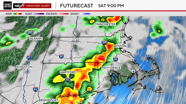
Storm threats Saturday night:
• Localized damaging wind gusts of 40-to-60 mph
• Isolated hail
• Brief heavy downpours
• Lightning
Timeline:
• 8 p.m. to 11 p.m.: Greatest risk thunderstorms
• Midnight: Any showers/storms dissipate or move offshore
• Sunday: A sunny start with increasing afternoon clouds and a few showers
Storms will develop across New York and Pennsylvania before pushing east into Massachusetts during the evening. Some of those storms could become strong enough to produce damaging wind gusts and isolated hail.
The primary concern locally will be strong to damaging straight line winds capable of bringing down tree limbs and causing isolated power outages. Brief torrential downpours are also possible.
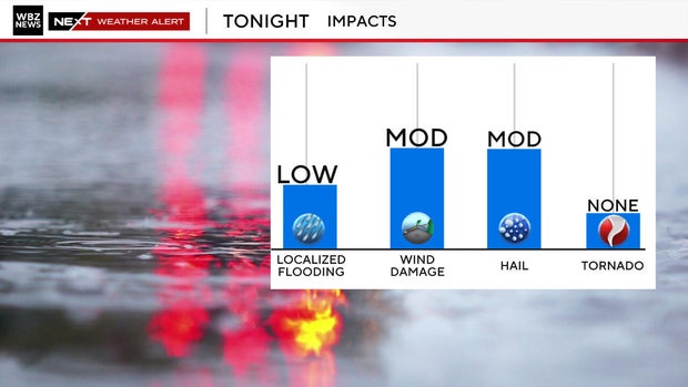
While widespread severe weather is not expected, any storm can always feature brief heavy rain and strong wind.
Sunday will start out bright and sunny with temperatures reaching the upper 70s to mid 80s before clouds build for the afternoon.
While scattered showers remain possible in the afternoon, much of the day will not be a washout.


