NEXT Weather: Tornado watch issued in PA, NJ, DE, & MD

PHILADELPHIA (CBS) -- Don't be lulled into a false sense of security in the afternoon when it's sunny with temperatures reaching the 70s!
We have a southwest wind this afternoon that will bring us some sun and make the atmosphere unsettled, feeding in moist, warm air that will set the stage for the evening and fuel those storms.
Saturday is a NEXT Weather Alert Day as we track the potential for severe weather.
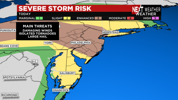
The threat encompasses the entire region including Philadelphia and the suburbs, the Lehigh Valley, South Jersey and all counties of Delaware. We are in the "slight risk" category for three main threats:
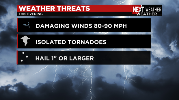
- Damaging winds
- Isolated tornadoes
- Large hail
The main timeframe of concern is between 4 p.m. and 10 p.m. Saturday, but we are under a wind advisory through 2 a.m. Sunday.
There's potential for power outages and downed trees or broken branches with those high winds.
Stay with the NEXT Weather team for updates today.
Severe weather threat ends
While the severe weather threat is officially over in the Tri-State area according to NWS Mount Holly, there is a wind advisory in effect until 2 a.m.
Power outages in the Tri-State area
With the Tri-State area under a tornado watch and severe thunderstorm warnings Saturday, there have been reports of outages in the area.
For PECO in Pa, there are 182 active outages as of 7:31 p.m. with over 17,000 customers affected.
Atlantic City Electric in New Jersey has 34 active outages as of 7:31 p.m. with over 3,000 customers affected.
Delmarva Power in Delaware and Maryland has 66 active outages as of 7:31 p.m. with over 7,000 customers affected.
Tornado warning in East Central Philly & Camden County
A tornado warning has been issued in North Central Camden County, Central Burlington County, and East Central Philadelphia County until 7:30 p.m.
Severe thunderstorm warning in Philadelphia & NJ
Areas of Philadelphia, Trenton, and Camden are under severe warnings until 7:30 p.m.
Tornado warning Northern Del and Southwestern Pa
National Weather Service confirms a tornado warning for Northeastern Sussex County in Southern Delaware in effect until 6:45 p.m.
There's another tornado warning in Northern Delaware around Northwestern New Castle County and in Southeastern Pa around Southwestern Chester County.
Tornado warning in DE counties
Officials confirm a tornado warning in Northern Delaware until around 6:30 p.m.
Warnings include Northeastern Sussex County.
Tornado watch issued in PA, NJ, DE, & MD
Severe thunderstorm warning in South Central Pa
National Weather Service in State College PA issued a severe thunderstorm warning in multiple counties in South Central Pa. until 5:30 p.m.
Those counties are:
- Northeastern Cumberland County
- Southern Dauphin County
- Northwestern Lancaster County
- Southwestern Lebanon County
- Northwestern York County
- Eastern Adams County
- Southeastern Dauphin County
- Lancaster County
- Lebanon County
- Southern Schuylkill County
- York County
Severe thunderstorm watch for Lehigh Valley
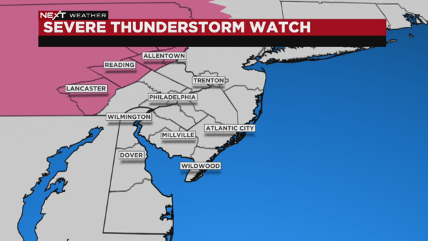
Multiple counties in Pennsylvania are under a severe thunderstorm watch Saturday.
The counties in our area are:
- Berks
- Lehigh
- Northampton
These other PA counties are under a severe thunderstorm watch:
- Adams
- Bedford
- Blair
- Carbon
- Centre
- Clinton
- Columbia
- Cumberland
- Dauphin
- Franklin
- Fulton
- Huntingdon
- Juniata
- Lancaster
- Lebanon
- Lycoming
- Mifflin
- Monroe
- Montour
- Northumberland
- Perry
- Schuylkill
- Snyder
- Sullivan
- Tioga
- Union
- York
NEXT Weather Radar: Where are storms in our area?
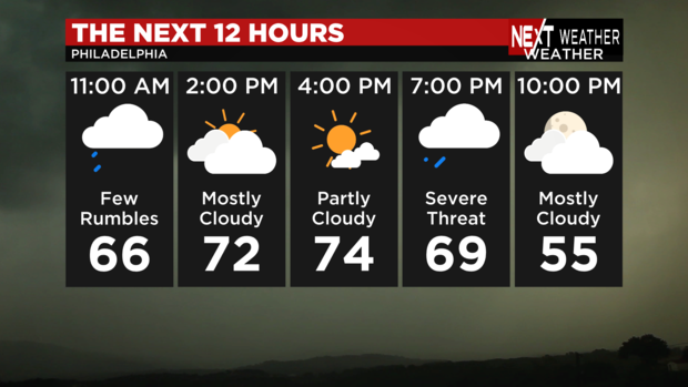
Impacts of Saturday storms
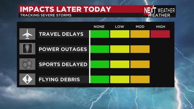
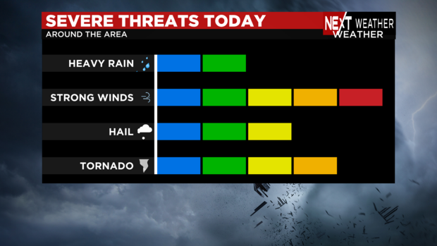
Damaging winds are possible throughout the day. We'll have gusts of 40 to 50 mph through the day and evening thunderstorm winds could be even higher.
Late afternoon and this evening, damaging winds of 80-90 mph are possible. Scroll down for more info on our wind risks.
Hail up to an inch wide is possible in spots.
The storms could bring travel delays, power outages, outdoor event cancellations and flying debris.
We also have a low, but significant, risk of tornado spin-ups.
Damaging wind risk increases in our area
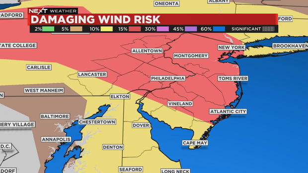
The risk of damaging winds in our area has increased to 15%.
That is huge in the world of weather. We are going to be looking at storms with damaging wind gusts from 70 mph to 90 mph.
T-storm risk upped for our area
We have some very strong, gusty low-level winds bringing plenty of warmth and moisture into the area, and we have now been upgraded into an enhanced risk of severe thunderstorms.
Much of our area, including the city of Philadelphia, is in the area facing a Level 3 risk on a scale that goes to Level 5.
This level 3 is what much of the Midwest was in Friday night.
We were previously under a "slight" risk.
This means we're looking at "more persistent and/or widespread" thunderstorms with a few intense storms as well.
We are monitoring the situation and will keep you updated.
Meteorologists Andrew Kozak and Bill Kelly will provide tag-team coverage of the storm this afternoon and evening.
Don't let afternoon calm fool you! Timing of the storms
This morning, a warm front lifted north of us and a cold front is ready to come by tonight.
In the 2 p.m., 3 p.m. and 4 p.m. hours, we'll dry out, but the atmosphere will percolate and become unsettled. Don't let the dry weather fool you, storms will be brewing!
After 5 p.m., isolated supercells will move across our area. There is enough spin at the low levels of the atmosphere that these could get going, with gusts of 40 to 50 mph.
There will be plenty of warmth and instability in the area, and that spin could lead to an isolated tornado, or a very strong damaging wind gust, a microburst with 70 to 90 mph winds.
The tornado threat is most pronounced at the Jersey Shore as the evening wears on.
Then the storms clear out, and temperatures will drop like a rock for a cold Sunday.
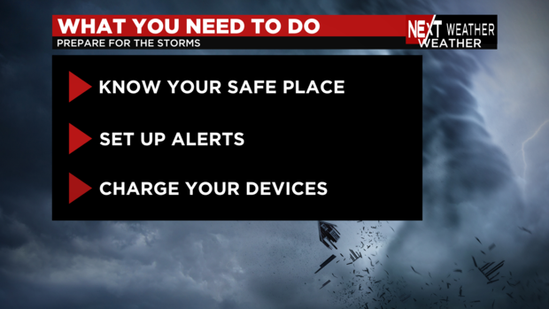
What to do to prep for storms
In case there's a tornado, you need to know what to do.
You need to know your safe place - where you can take your kids, pets and other loved ones in the event of a tornado warning.
Set up alerts on your cell phone - you can download our CBS Philadelphia app and we will keep you updated.
- Have an Android device? Click here to get the CBS Philadelphia app on the Google Play Store
- Have an iPhone or other Apple device? Click here to get the CBS Philadelphia app on the App Store
And keep your device charged in case of any power outages.
Tornado, hail risk across our region Saturday
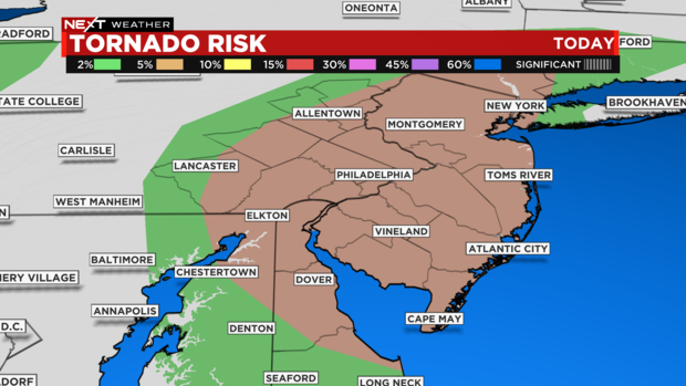
Yesterday, tornado risk was projected to mostly be along the Jersey Shore, but that area of risk has expanded to our entire region except for the Poconos.
While the map says the risk is 5% and that doesn't sound like much, in the weather world, it is a big number. There is enough spin in the atmosphere that we can't rule out the chance of isolated tornadoes.
Hail risk
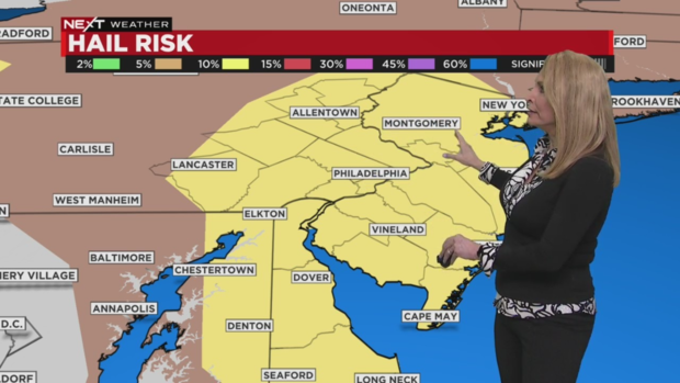
Hail risk is at 10% as well - we could see hail up to 1 inch.
Damaging winds: what you need to know
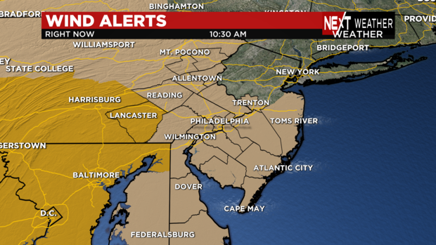
The entire region is under a wind advisory through 2 a.m. Sunday.
Lancaster County, Pennsylvania and other counties to our west are under a high wind warning.
Even before the evening round of storms arrives, we are looking at winds that will gust 40 to 50 mph.
Those winds are separate from any thunderstorm winds we'll see in the evening. Those could exceed 60 mph.


