Heavy rains bring flooding to parts of the Tri-State Area, along with a tornado warning

The Tri-State Area is getting another soaking Tuesday.
Bands of heavy rain are creating hazardous conditions. A Flash Flood Warning was in effect late Tuesday night into early Wednesday morning for parts of New Jersey, Manhattan and Staten Island through 12:45 a.m. Wednesday morning. Earlier Tuesday afternoon, a Tornado Warning was issued for Sussex and Warren Counties in New Jersey. It was followed by a Severe Thunderstorm Warning in the same area.
Check the latest weather watches, warnings and alerts
The cell that was causing concern brought with it intense rains and lightning. Rainfall rates were at up to two inches per hour as the front moved through quickly, heading northeast through Sussex and Warren Counties at around 40 mph.
In the event of a tornado, the safest areas in a home are typically basements and the lowest interior room in the home. Stay away from windows, and get under something sturdy. You can also cover yourself with a blanket or a mattress. In the worst case, you can get into a closet.
So far, there have been no reports of any actual tornado touchdowns.
All of the moisture in the air has been creating ripe conditions for strong storms.
A flood watch has been issued for most of the Tri-State Area, including New York City, as rain and potentially strong storms are set to move through.
The National Weather Service has issued the watch from 8 a.m. Tuesday through 8 p.m. Wednesday.
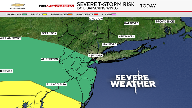
Most of New Jersey is under a severe thunderstorm watch through Tuesday evening.
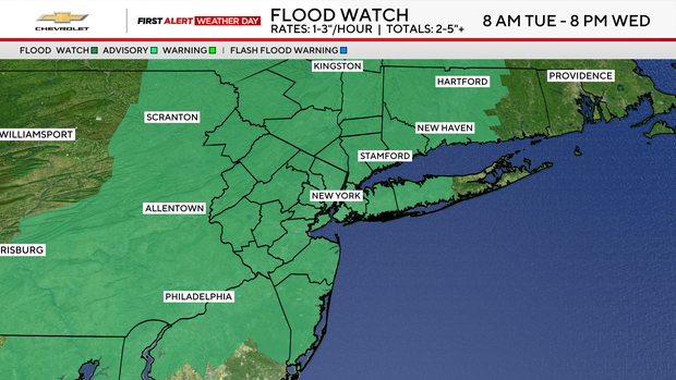
Tuesday and Wednesday are First Alert Weather Days for flash flooding.
There are also dangerous rip currents from 6 a.m. to 9 p.m. Tuesday for beaches south of the city and on Long Island.
New York City is opening a variety of safe overnight locations at schools for people to use in the event of flooding. For more information about that, click here.
"We expect heavy rain and thunderstorms to cause flash flooding around the state," Gov. Kathy Hochul said Tuesday. "We're coordinating with local emergency management teams, absolutely preparing for the worst. This includes staging swift water rescue teams in case they're needed, and deploying our resources everywhere."
Hochul urged people to avoid driving through any floodwaters, pointing out only a foot of water is enough to "turn a vehicle into a boat and out of control."
The Mets game against Atlanta Tuesday night was postponed due to the weather.
Heavy rain Tuesday afternoon
The morning starts off humid with patchy fog, but conditions will deteriorate in the afternoon with scattered downpours and flash flooding.
Rain could fall at one to three inches per hour, totalling two to five inches or more.
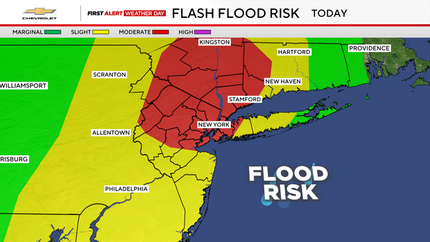
Unlike last week, when all severe hazards were on the table, this Tuesday's greatest hazard from thunderstorms will be torrential downpours that may lead to flash flooding.
Damaging winds and hail are still possible too, with the greatest chance of those occurring well to the south and west of the city.
The heavy rain threat continues Wednesday but doesn't look as prolific or widespread.
Temperatures will run below normal, ranging from the upper 70s to low 80s, and it will feel tropical at times.
Weekend weather shaping up
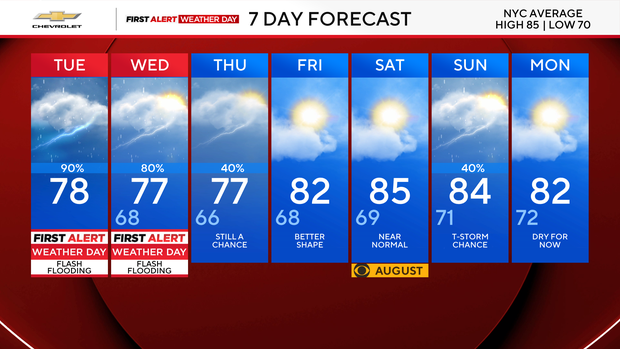
Things are looking up for the weekend with Friday and Saturday looking dry.


