Cold temperatures in NYC stick around Saturday after Code Blue overnight
Cold, windy weather blew into the New York City area just in time for Thanksgiving, triggering a Code Blue, and it's expected to stick around for the holiday weekend.
The First Alert Weather team is also tracking chances for rain, snow or a wintry mix next week across the Tri-State Area.
Here's what to know for your travel and shopping plans.
Cold weather arrives for the holiday weekend
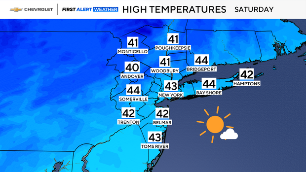
A mostly sunny, but brisk day is in store for Saturday. Highs in the low to mid 40s will actually feel like the 40s without a biting wind in place.
New York City issued a Code Blue, encouraging vulnerable New Yorkers to find shelter from the cold, overnight Friday. Under a Code Blue, the city's Office of Emergency Management deploys outreach teams to make sure anyone experiencing homelessness can access a place to stay.
Winds relaxed a bit overnight. However, it was still quite cold, with lows in the mid 20s to low 30s. Windchills hovered in the lower 20s.
Tracking our next chances of rain or snow
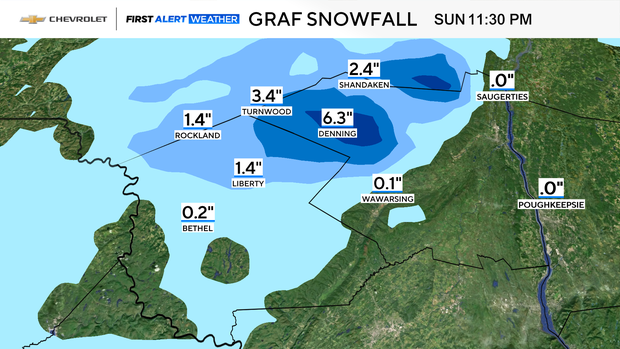
A First Alert Weather Day has been issued for Sunday, due to rain and a bit of wintry weather far north and west that may effect holiday travel.
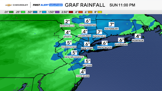
While the system anticipated to move through that day will mostly be a rain event, some snow is possible in our far northwestern zones. In these locations, mainly in the higher elevations of Ulster County, up to 6 inches of snow may fall.
Elsewhere, rain that may be heavy at times, should amount to .25-.50 inches. Outside of the higher elevations, temperatures will briefly warm up, pushing 50 degrees in many locations.
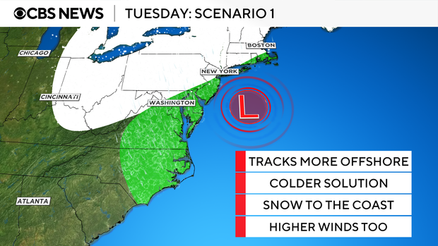
Sunday's system will quickly move out by Monday, leading to a dry and cold day. The break does not last long though, as our second First Alert Weather Day is poised for Tuesday. During that day, the first winter storm of the season is anticipated to effect the entire Tri-State Area. The final outcomes of this storm are still evolving and will get fine-tuned as the weekend progresses.
In scenario 1, the storm would bring mostly rain to a large portion of the area before changing over to snow as it departs. Meanwhile, areas to the northwest would see mostly wintry precipitation throughout the duration of the event.
In scenario 2, the storm would track closer to shore, bringing rain for even more locations, with snow mainly confined to far northwestern zones.
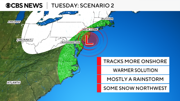
In both scenarios, heavy rain is likely. High winds may also be a factor, especially at the coast. Regardless of whether the storm is more wet than white, it will be disruptive for everyone.
Following Tuesday's storm, a cold pattern settles in place through next weekend.