Storm leaves behind lingering St. Patrick's Day rain showers
Stormy weather arrived overnight around the New York City area, bringing heavy rain and high winds.
Monday is a First Alert Weather Day for the possibility of flash flooding, downed trees, wires and debris on roadways during the morning hours.
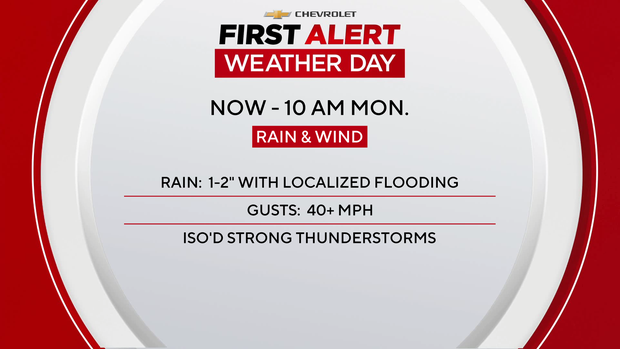
The massive storm system that pummeled portions of the Midwest and South with deadly tornadoes, as well as numerous other hazards, moved into our region overnight.
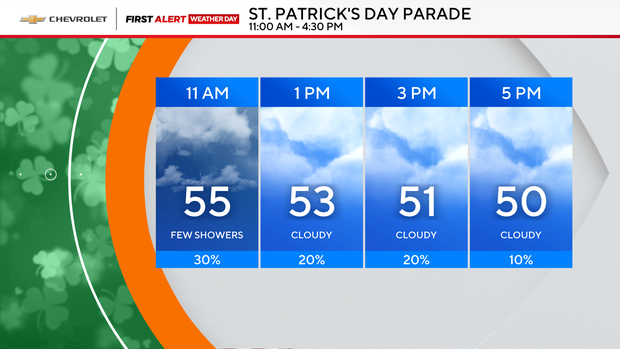
Monday kicked off with heavy rain across the city and Long Island. But all things considered, the remainder of St. Patrick's Day won't be so bad.
The good news is the parade got off without a hitch, with only a nuisance shower expected from time to time. Temperature-wise, it's pleasant, with highs in the 50s.
NYC weather this week
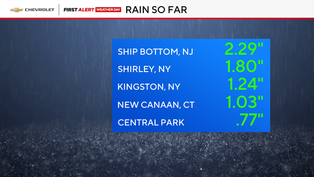
Rainfall ranged from 0.5" to 2" into this morning, with exceptionally higher amounts along the Jersey Shore. Unfortunately, we'll be dealing with some lingering showers the remainder of the day, especially east.
Things will finally clear out tonight, but it will be colder out there. Expect wind chills to fall into the 30s and 20s by daybreak.
We're serving up one of our "Picks of the Week" on Tuesday, as we're expecting plentiful sunshine with highs around 60. Our second "Pick of the Week" will arrive on Wednesday, with highs around 60 again.
As for the remainder of the week, we ring in spring at 5:01 AM on Thursday, with another round of rain expected that night into early Friday.
Live radar around Tri-State Area
Stick with our First Alert Weather team for the latest forecast, live radar and weather alerts.