Black ice warning in NYC area as temperatures plummet. Here's the timeline for the deep freeze.
Bitterly cold temperatures are causing icy road conditions, including black ice, in the New York City area after several inches of snow fell over the weekend.
Mayor Eric Adams announced alternate side parking regulations are suspended Monday for snow removal.
Monday's frigid forecast
In the wake of a storm that dropped on average 3-6 inches around the Tri-State Area, arctic air has funneled back into the region, ensuring that the snow on the ground won't melt that quickly.
Temperatures were stuck in the single digits on Monday morning, and the afternoon didn't offer much relief, as highs didn't get out the 20s for most locales.
Besides feeling miserable, the bitter cold has created icy and dangerous conditions on roadways and sidewalks, so take it slow.
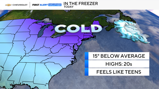
A few snow showers are possible Monday night, but very little accumulation is expected. Wind chills will dip into the teens and single digits, making it one of the most frigid nights of the season so far.
Black ice warning
As the frigid weather settles in, snow is no longer the main concern in areas like Milburn, New Jersey, which got up to 6 inches over the weekend.
New York City's Department of Sanitation was out early Monday morning salting roads, but drivers and pedestrians should continue to remain on alert for dangerous black ice and other slick hazards.
"We are focusing on some of the highways, because that's where we saw overnight some of the melting and refreezing," Acting Sanitation Commissioner Javier Lojan told CBS News New York. "We have been monitoring those roadways consistently throughout the night and readdressing as necessary going into this morning."
The DSNY said trucks and salt spreaders cleared every road, but would double back to try and eliminate black ice, especially on highway ramps and side streets.
The most treacherous places to drive on are overpasses, bridges and shaded areas, where the sun isn't able to reach, according to officials.
Tuesday-Friday forecast
Cold temperatures will still be in place on Tuesday, with highs only in the low 30s, but then a brief warmup will begin midweek. We'll go from average highs in the mid 40s on Wednesday, to above-average highs in the 50s on Thursday and Friday.
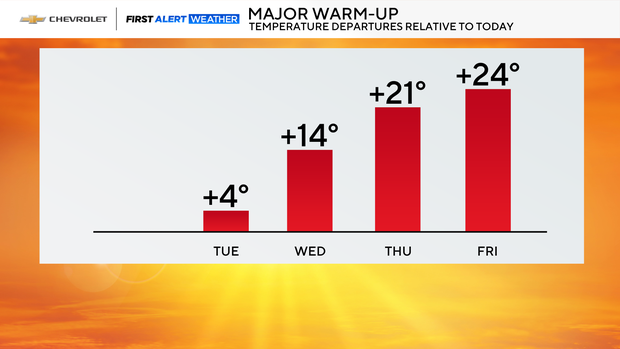
The welcome break from the frigid temperatures will come with a chance for a good soaking of rain from late Thursday into Friday.