Warmer weather finally sticks around the New York area this week. Get the First Alert Forecast.
After the coldest winter in 11 years, New York City and the Tri-State Area are finally turning the corner to a consistent warm pattern this week.
New York City fell to 30 degrees on Wednesday, but this week we could hit 80! On average, in the past 30 years, the last freeze has happened on March 29. So, we are 10 days late this year.
Temperature roller coaster
It has been a temperature roller coaster this spring; the city already recorded three days in the 80s. In fact, our first 80 this year was on March 10, making it the earliest 80 degrees on record.
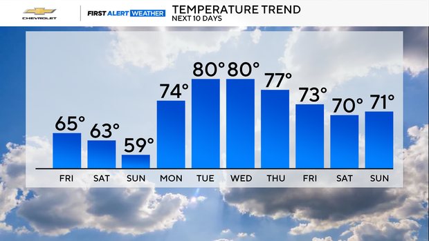
So far this spring, our warm spells have not lasted long, just a few days, but that is about to change this week. The forecast calls for a persistent warm pattern to last all of this week with temperatures climbing into the 70s and 80s.
The average high temperature for middle of April is only in the lower 60s; this will put us 15 to 20 degrees above normal.
Abnormally dry conditions
With warm weather, we will have to dodge a few April showers, but no major rain is forecast.
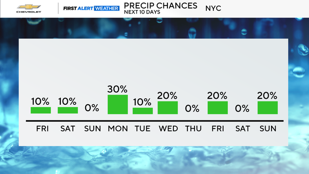
With the lack of rain, the Tri-State Area has been placed under Abnormally Dry conditions by the U.S. Drought Monitor.
Sussex, Passaic and Morris counties in New Jersey are under a Moderate Drought.
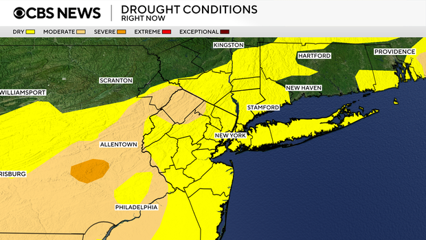
Year to date, New York City is more than 3 inches below normal for precipitation.
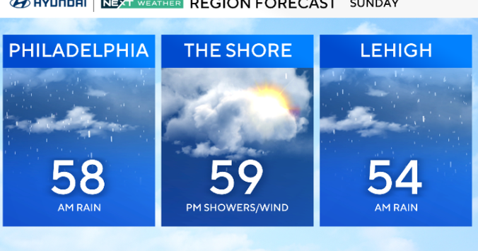
Weekend forecast
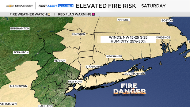
A Special Weather Statement is in place on Saturday for all of New York City, Long Island and the Hudson Valley due to an elevated risk of wildfire development. With very low humidity levels and wind gusts between 25-35 mph, any fires that break out will be able to spread easily and rapidly.
Brilliantly blue skies made for a simply stunning Saturday. Even with breezy conditions, it still felt wonderful.
For tonight, the clear skies will remain in place, but the winds will gradually decrease overnight. The combination of clear skies and lighter winds will make for a chilly night, with lows ranging from the 30s across the suburbs, to the low 40s in the city.
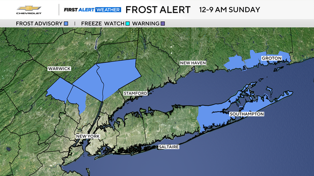
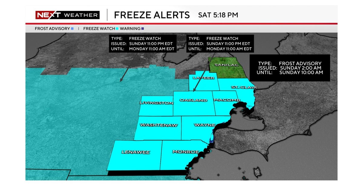
Some frost is possible, especially for the most outlying suburbs. Even though we are now in mid-April, frost development is still a fairly common occurrence.
A Frost Advisory in place from midnight through 9 a.m. Sunday for eastern Suffolk and northwestern Westchester, counties, along with Passaic, Bergen and Rockland counties.
For Sunday, the risk of wildfire development decreases, as an onshore flow brings up relative humidity values. With breezy conditions returning late in the day, there still is a slight risk of wildfire development, though. The other result of the onshore flow will be cooler daytime temperatures, with highs getting stuck in the 50s for most locations.
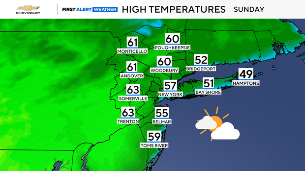
Bright skies in the morning will give way to more clouds by the afternoon hours. A stray shower is possible, but mainly north of the city. The cooler readings will be short-lived.
Beginning Monday, and lasting through most of this week, a summer-like weather pattern featuring highs in the 70s and 80s will take over the Eastern Seaboard. It's even possible that some record highs get set. Some inland locations may reach 90 degrees.