NYC in for more brutal cold this weekend
Bundle up — New York City and the Tri-State Area's stretch of dangerously cold weather continues, and it's sticking around longer than anyone would like.
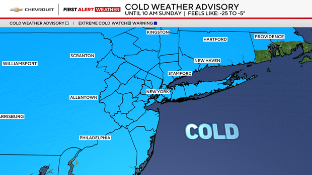
Saturday and Sunday are First Alert Weather Days due to dangerously cold temperatures and wind chills. A Cold Weather Advisory has been extended until 10 a.m. Sunday for most of New Jersey, and a Coastal Flood Advisory is in place for Ocean County from 5 a.m until noon Sunday.
Friday marked our seventh straight day of not reaching the freezing mark, as brutally cold temperatures maintain a firm grip on the Tri-State Region.
After a wicked cold start to the day, high temperatures on Saturday, still albeit, frigid, will reach the low to mid 20s. Those temps might actually feel somewhat better, especially with decent amounts of sunshine in place.
The highly publicized snowstorm that was on the table for Sunday no longer poses a significant threat to our region. That large and powerful storm will, however, deliver a sizable amount of snow to the Carolinas and Virginia, before safely moving out to sea.
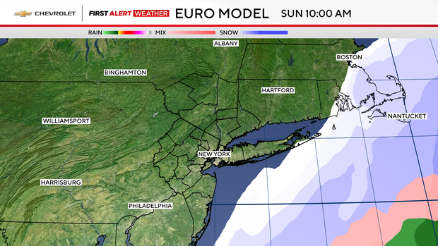
Due to the storm's strength and size, we will still see some fringe effects though. These effects will play out on Sunday and would be mainly confined to coastal locations.
Such effects would include minor coastal flooding, enhanced by the upcoming full moon, which may reach up to 1 half foot of inundation. Eastern Long Island could also see a light amount of snow, totaling no more than a half an inch.
In terms of winds, Sunday does look to be a windy day for all locations, gusting between 25-40 mph. Coastal areas will likely experience higher gusts that may reach 45-50 mph.