How many inches of snow are expected in Friday's storm? Maps show what to expect, and when.
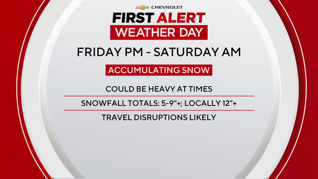
It's a First Alert Weather Day for Friday evening into Saturday morning due to accumulating snow that could be heavy at times.
New York and New Jersey were under states of emergency.
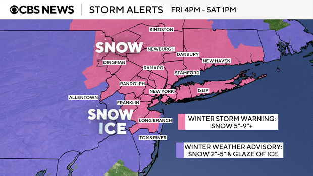
A Winter Storm Warning in place for the most of the entire Tri-State Area, except Hunterdon and Ocean Counties from 4 p.m. Friday through 1 p.m. Saturday.
Winter Weather Advisory in place for Hunterdon and Ocean Counties from 3 p.m. Friday through 10 a.m. Saturday.
Click here to get the latest winter storm watches, warnings, advisories and alerts.
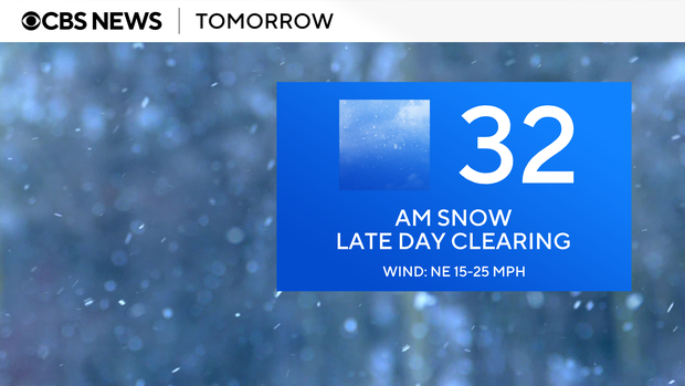
Details on the NYC snow forecast
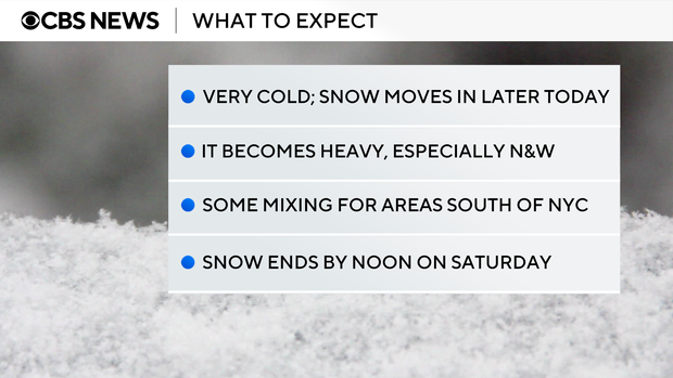
Clouds have filled back in advance of a significant winter storm that will bring widespread impacts to the Tri-State Region from Friday evening into Saturday morning.
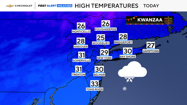
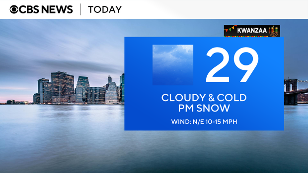
With highs only in the upper 20s to low 30s Friday, the main impacts would mainly be heavy snow. Some mixing with sleet and freezing rain is possible well to the south and west of the city.
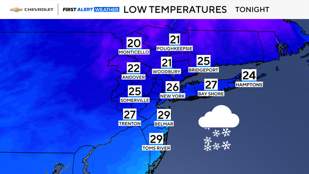
Thankfully, high winds are not anticipated to be an issue with this storm. Lows Friday night will stay in the 20s.
New forecast model data has led us to believe that a general 5–9-inch snowfall is likely with this system.
Areas to the north may see higher totals, which is where heavier bands of snow are expected to set up. Pinpointing exactly where the heaviest bands set up is a challenge, and a slight shift to the south could put NYC into a higher range, meaning totals of over 10 inches potentially. Meanwhile, areas to the south and west of the city may see much lower amounts of snow. This is due to some warmer air in the upper levels of the atmosphere moving over the very cold air already in place at ground level.
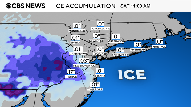
As a result, more sleet, and even some freezing rain, would mix in with the snow.
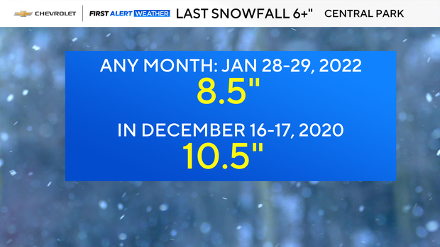
As everyone knows, substantial snowfall in and around New York City has been hard come by for the last several years. If the 4–8-inch range forecast verifies, it would be the most snow in the city since late January 2022, when a strong coastal storm put down 8.5 inches in Central Park.
After the snows clears out by Saturday afternoon, highs will only reach the lower 30s. Temperatures warm slightly by Sunday, reaching the upper 30s, but it comes with a rain chance later in the day.
Timeline of the snow storm
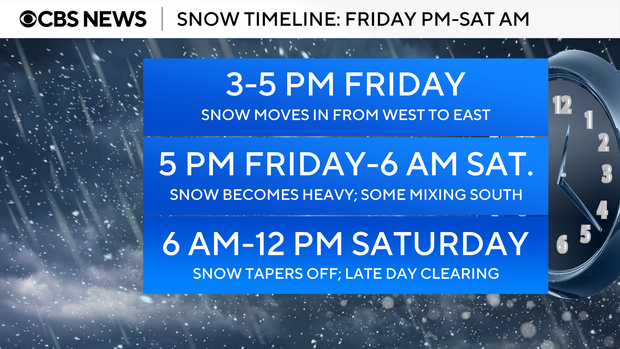
3 p.m.-5 p.m. Friday
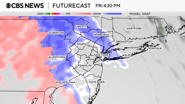
As a wave of low pressure develops along a stationary front, snow will move into our region from west to east. Initially, it will be on the light side, but as the evening progresses, it becomes moderate to heavy. With high temperatures below freezing on Friday, the freezing line will be well to the south of NYC, so precipitation type won't be a question at first.
5 p.m. Friday-6 a.m.Saturday
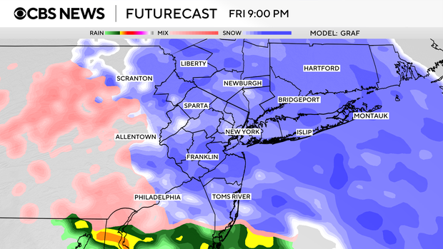
Prime time of the storm. Snow is likely to be very heavy at times. Snowfall rates may reach 1-2 inches per hour during this timeframe, leading to quick accumulations. For areas south and west of the city, some mixing with sleet and freezing rain is possible, especially in western portions of Hunterdon, Monmouth, and Ocean Counties. This may cut down snow totals there. No mixing is expected for areas to the north.
6 a.m.-12 p.m. Saturday
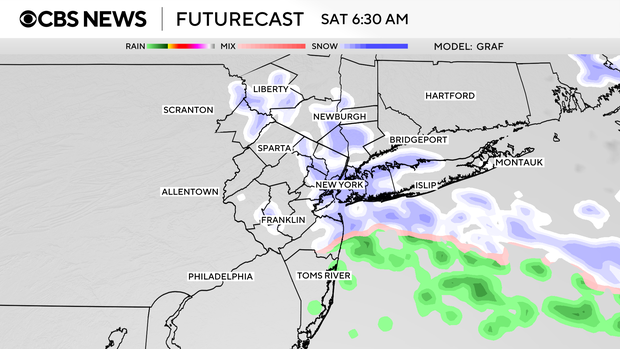
The storm starts winding down. Precipitation ends from west to east. A general 5–9-inch snowfall is anticipated, with higher amounts north and west of the city, and lower amounts southwest of the city. Skies may even clear just in time for a nice sunset. With a fresh snowpack and clear skies, temperatures on Saturday night will plummet quickly back into the 20s and teens, leaving untreated surfaces icy and dangerous.
Expected snowfall totals by region
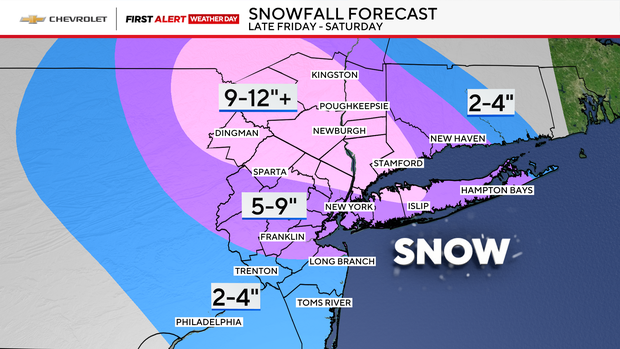
NYC: 5-9"
Long Island: 5-9" for Nassau and much of Suffolk County, 9-12" in certain spots along the North Shore
Central Jersey and Jersey Shore: 5-9". 2-4" for Ocean County and central and southern Monmouth County. A light glaze of ice is likely in these areas as well.
Northern New Jersey, Lower Hudson Valley, and Connecticut: 5-9". Locally, higher amounts are possible.
Upper Hudson Valley and far Northwestern New Jersey: 8-12". Locally, higher amounts are possible.