Wind advisories in New York City area after dense fog Monday. Here's the forecast.
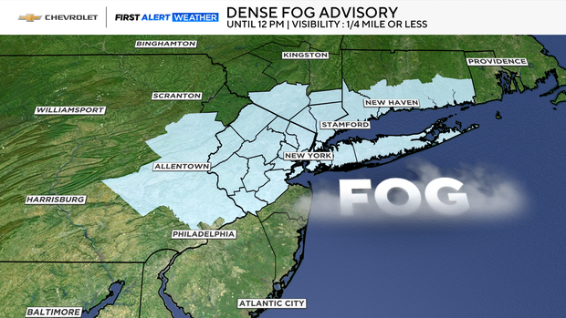
All of New York City was under a dense fog advisory Monday morning, with warmer air in place after freezing rain in the Tri-State Area overnight.
The dense fog advisory was in effect through 12 p.m. and also covered the following counties in New York, New Jersey and Connecticut: Sullivan, Sussex, Warren, Morris, Hunterdon, Somerset, Middlesex, Bergen, Passaic, Hudson, Union, Essex, Orange, Rockland, Putnam, Westchester and Fairfield.
Meanwhile, a wind advisory is in effect for most of New Jersey and Sullivan County, New York, from 10 a.m. Monday through 1 p.m. Tuesday due to wind gusts in the 40-50 mph range, causing severe windchills.
Monday forecast
With warmer air in place this morning, any leftover freezing rain will have since changed over to plain rain for all locations. Rain may briefly become heavy before clearing out in the afternoon hours.
Before skies clear, temperatures will move into the low 50s for a short period of time, melting whatever snow is left on the ground.
The clearing skies are associated with another shot of arctic air that moves in by Monday evening.
Along with dropping temperatures, high winds will also return Monday night into Tuesday. During this timeframe, wind gusts could get as highs as 50 mph at times, leading to biting windchills in the teens and single-digit temperatures.
Arctic air will then remain in place through the beginning of 2026.