First Alert Weather: Yellow Alert for lingering rain, wind and snow
NEW YORK -- A winter storm moving through our area is creating messy conditions.
The CBS2 First Alert Weather team issued a Yellow Alert on Friday for leftover rain and snow, and potential coastal flooding, as the storm wraps up.
See live updates below for latest team coverage.
Residents unfazed by season's first winter storm
A little extra time was all some Orange County residents needed to dust off their cars and salt their sidewalks Friday morning after a few inches of snow fell.
Angela Storms was out bright and early to shovel in front of her Middletown deli. Waking up to flakes wasn't so terrible, she told CBS2's Zinnia Maldonado.
"If you look at all the lights, it's pretty, but icy, and it's icky, and it's heavy," said Storms. "The roads weren't too bad but the sidewalks and stuff, they're pretty slippery. So it's just getting everything cleaned up."
A plow truck driver said he was relieved the last 24 hours weren't too busy as roads were able to be cleaned up pretty quickly. Those getting around on foot agreed.
"It doesn't look as bad as I thought. It's not so bad," one person said. "This is a minor storm at this point. Hopefully we won't get more."
"It's not bad. I really like the snow. Sometimes driving it's a mess, but I think it's great," said another.
Middletown resident Oswaldo Diaz said his Friday morning commute was a lot better than the one Thursday afternoon.
"So far it's what, raining, slush, icy, not like yesterday. Yesterday was the worst. Coming back home was bad. I had to drive like 35 miles," said Diaz.
Not long after the first snowflakes started coating the roads, Orange County Emergency Management reported a spike in car accidents. Thankfully, there were no major injuries.
Orange and Rockland Counties reported nearly 400 customers lost power Thursday night, mainly in Monroe. Power has since been restored to those customers, but crews remain on standby to repair any damage or outages left behind.
Friday morning forecast
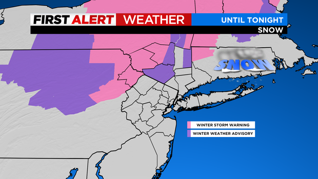
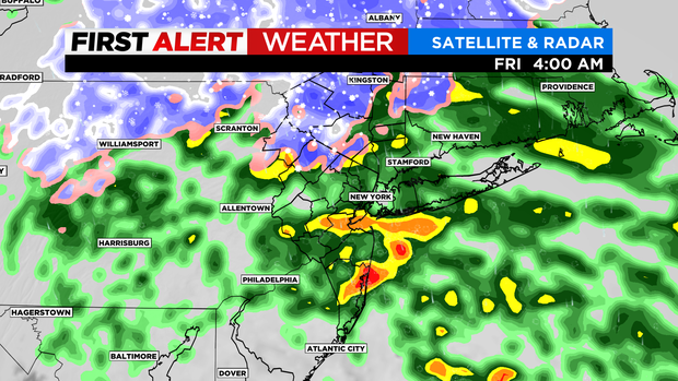
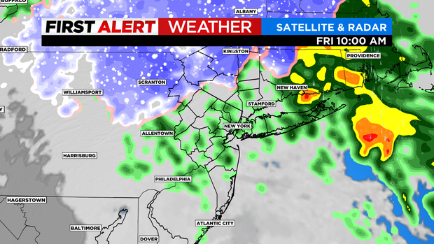
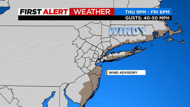
Alerts: Red Alert this morning. Yellow Alert from noon until this evening for leftover rain/drizzle, leftover snow N&W, blustery conditions and some minor coastal flooding.
Advisories:
- Wind Advisory until 4 PM along the NY/CT coast (including the Bronx and northern Queens) for wind gusts of up to 50 mph.
- Coastal Flood Advisory for much of the coast until this evening for minor flooding during highs tides.
- Winter Weather Advisory/Winter Storm Warning well N&W until this evening for additional light accumulations.
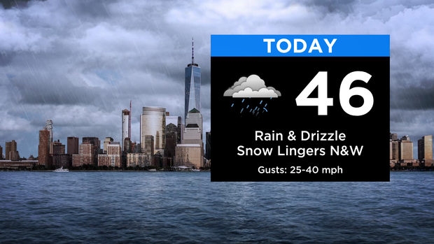
Forecast: Rain/showers gradually taper off through the day with the last of the rain exiting this evening. Snow will linger N&W, as well, with perhaps some light additional accumulations this afternoon into this evening as our storm pulls away. Winds peak this morning/midday around 30/40 mph (50 mph along the coast), then gradually weaken through the day. It will remain breezy tonight, but the clouds will break up overnight with temps falling into the 30s... wind chills in the 20s.
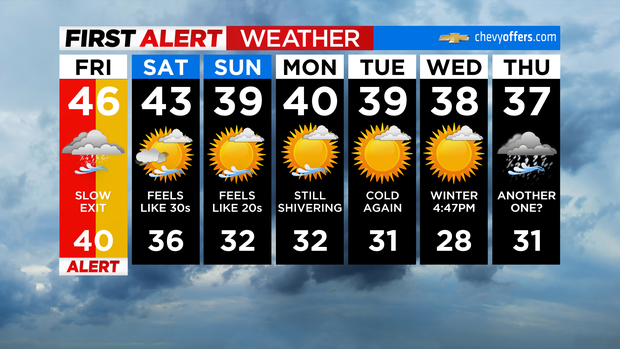
Looking Ahead: Brighter this weekend, but cold. Feels like the 30s tomorrow... 20s on Sunday. Temperatures will be below normal into the start of next week, but no active weather is expected at this time.
NY DOT crews out 24/7
New York State Department of Transportation Commissioner Marie Therese Dominguez joined CBS2 by phone Friday morning with an update on road conditions.
"I'm happy to report that the state roads in the area are open and traffic is flowing, and I think that's in good part thanks to the good work of our crews who have been out all night dealing with the range of mixture that's falling in the area," she said.
Dominguez said crews have been working around the clock and will continue through cleanup.
NJ DOT treating slushy roadways
New Jersey Department of Transportation Senior Director of Operations Chris Feinthel joined CBS2 by phone Friday morning with an update on road conditions.
"We're fighting a couple different fronts. There's coastal flooding. The wind is picking up, so there's a few trees and power lines down, really kind of in Central Jersey right now, so we're deal with that. Then we're still wrapping up with pushing back some snow up in Sussex County in the higher elevations," he said.
Feinthel said most roadways were coated with slush, which the winds should help dry out during the day.
"It's an event like this that can be a little tricky for us. Folks hear 1 to 2 inches and they're not that concerned with that. But this heavy, wet, slushy snow can create a glaze on the roadway," he said. "It's difficult for us to maintain and treat, and it's just something that we have to stay on top of."
Northern suburbs bearing the brunt
Areas north and west of New York City are seeing the biggest impact from the storm, including western Orange County.
No state of emergency or travel restrictions have been put in place, but a winter weather advisory remains in effect there until 10 a.m.
The snow started to fall late Thursday and began to coat roads. Shortly after, Orange County Emergency Management started reporting an increase in car accidents. Thankfully, no major injuries have been reported.
Orange and Rockland reported nearly 400 customers lost electricity overnight, mainly in Monroe. Power has since been restored to those customers. Crews remain on standby to repair any damage or outages left behind by the system once the sun comes up and we get a better look at the area.
You may want to get outside a little earlier than usual to get your car warmed up and scrape off any ice. The conditions could still impact the morning commute, and county officials urge people to avoid traveling if possible. If you do have to be out there, your best bet is to leave early and drive slowly.
Checking on road conditions in N.J.
Steady rain floods Queens streets, frustrating residents
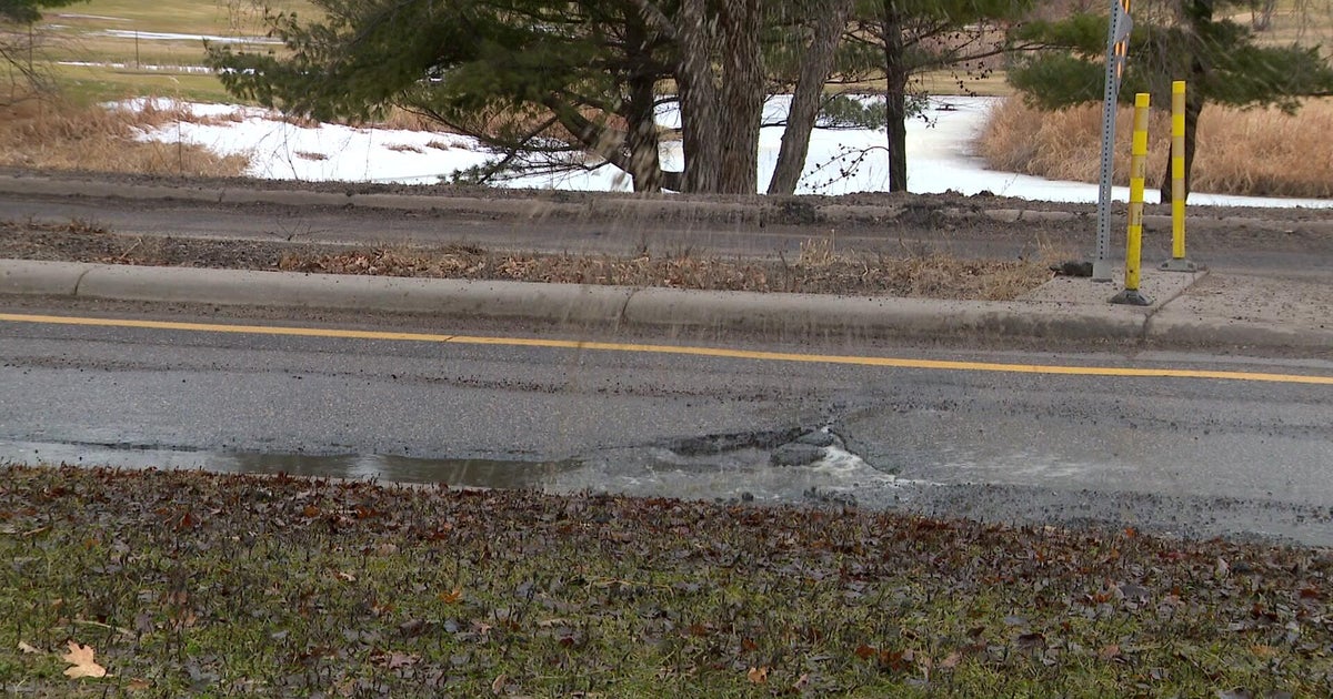
The rain was steady in Queens on Thursday, and while there was not a lot of heavy downpour, it was enough to cause flooding along several streets in Rosedale.
Residents told CBS2's Jennifer Bisram it's been happening for years and they're fed up.
The rain made it hard to get around Thursday night.
"All this water and it's not that much heavy rain. It's light rain, so you can imagine when it's heavy rain, it's up to sidewalk," said Shashala McGregor.
There were several inches of rain around McGregor's Queens home, and she says it happens often.
"You can't cross the street and the sewage backs up, and sometimes, if it rains hard enough ... it can go into my basement," she said. "I'm afraid that it also poses a risk to my plumbing 'cause it's frozen to the ground, and if somebody slips and falls because of water and ice, I'm going to be responsible."
McGregor says she's called 311, the DEP and the commission office of Rosedale, but no one has been able to help.
"Nothing has been done," she said.
The city did complete a $17.3 million sewer and street upgrade back in 2021 in Rosedale to help alleviate flooding, but McGregor says they didn't get to her block on 147th Avenue just yet.
"They should just come and fix it," she said.
CBS2 reached out to the DEP to see if there's anything that can be done to help families around this particular area.
The DEP responded, "If homeowners experience any flooding issues they should report it to 311 and DEP crews will respond and investigate. The City has recently invested $2.5 billion in southeast Queens to build a comprehensive drainage system to improve street conditions and minimize street-level flooding during heavy rainfall events. However, we are seeing the effects of climate change with the frequency and intensity of rainfall."
Live radar & maps
CLICK HERE to see the very latest track of the storm.
8 p.m. Thursday weather update
Alerts: Red Alert in effect through at least Friday morning.
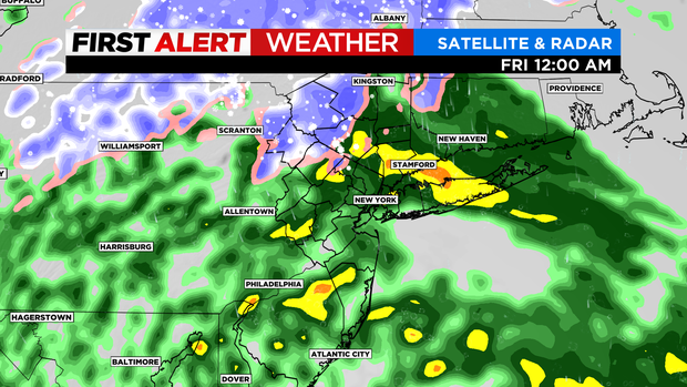
Rain: Heavy slugs of rain are creeping through the area with the rain/snow line slowly receding north through Morris and now Sussex counties in New Jersey. We should end up with 1-2 inches of rainfall across the area.
Snow: We've already seen 2-3 inches of snow in northwest New Jersey, with another round of snow falling right now. More snowfall is expected in Sullivan, Ulster and northwest Orange counties overnight as those elevated zones (750-1000+ feet) remain cold.
Wind: A Wind Advisory goes into effect at 9 p.m. for the New Jersey shore, and they kick in overnight for Connecticut and Long Island with gusts to 50 mph. These are strong enough for some damage.
Again, the windswept rain will fall overnight with some moderate bouts sticking around for the Friday morning commute.
As Friday progresses, the system pivots to exit, but not before putting down another burst of snow north of New York City. This could definitely tack on some additional snowfall numbers.
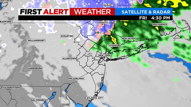
Around 5 p.m. Friday, the low really starts to pull away and we finally shut of the precipitation. Expect a slow go Friday morning, especially north with widespread slick spots due to the rain/snow mix.
Coastal Conditions: A strong and steady east wind will create some minor coastal flooding conditions for portions of the Jersey Shore and the Long Sound mainly during high tide cycles. (High tide is around 12:30 p.m. at Belmar, New Jersey). There is marked improve down the shore by Friday afternoon, but the winds get stronger over Long Island as the storm pulls away. The Wind Advisory is in effect for Eastern Suffolk until 6 p.m. Friday.
Morris County, N.J. gets jumpstart on inclement weather to come
There has been a mix of rain and sleet across New Jersey.
In Morristown, it has been more about freezing rain and snow, but not much is sticking to the ground because temperatures have stayed above freezing for the most part. The weather, though, has been a reminder for many to prepare for the winter.
One man was using small salt spreader to keep the sidewalks from freezing over. Others headed out early to local stores to buy winter essentials.
"I just bought some rock salt," one person said. "I am preparing, you know, I don't want to come too late when they're out of this stuff."
"I got some salt for the ice and the storm that's coming and some plant bottom things. Yeah, that's all I need," added Joel Familia of Randolph.
CBS2 found trucks salting local roads, and drivers taking it slow.
At Morris County's garage, the dome was filled with plenty of salt. The county activated its own drivers, as well, as contractors to cover more than 300 miles of roads.
"We're concerned with all of our roadways. We're certainly concerned with our hills and valleys and areas that have shade," said Jeff Paul, Morris County's director of emergency management. We're taking it in stages, as far as storms go, prepping us up for the big one."
The weather has been nasty enough for those walking. Many got out their heavy winter coats. However, one mom, who is originally from Minnesota, said she is not worried about this Jersey storm.
"This is nothing. My mom sent me video and they've got tons of snow. This is pathetic," Rhonda Mason of Morristown said.
But it is a good time to stock up on winter home and car essentials, items like flashlights and shovels.
Also, if you're heading out on the road, make sure to fill up your gas tanks and give yourself plenty extra time.
MTA salting Metro-North line
The MTA says crew members are salting Metro-North platforms and staircases ahead of the storm. The agency expects the railroad to run on a normal weekday schedule.
MTA bridges and tunnels will ban empty tractor-trailers beginning at 10 p.m. Thursday until 2 p.m. Friday because of gusty winds.
Pedestrian walkways at the Cross Bay Bridge and Marine Parkway Bridge will be closed during the same time. Walkways at the RFK Bridge and Henry Hudson Bridge may also close, depending on conditions.
Morris County preparing for measurable snow
While much of New Jersey is expecting rain and sleet, Morris County may see up to 3 inches of snow.
As CBS2's Christine Sloan reported, it was a busy morning for county workers.
Salt trucks are on standby, with drivers going in and out of the yard. They're positioning themselves on key roadways and highways, ready to spray a solution of salt to help prevent icing.
Emergency management officials urge drivers to take it slow and pay attention to speed restrictions on highways, like Route 287.
Sloan also spoke with those helping the homeless population in Morristown, like Market Street Mission which opened its doors to people struggling to stay warm.
"We do emergency care. This would be a code blue situation, so we will have people off the street come and have emergency shelter," Susan Bosworth, with the mission told Sloan.
There are 300 miles of roadway in the county, so crews will be very busy all morning and into the afternoon.
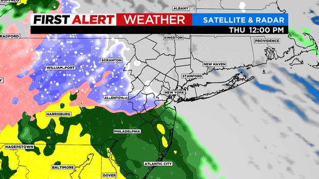
Thursday morning forecast
Timing
11 a.m. - 3 p.m. Thursday: Rain and snow enter the region, from the southwest, and expand northeast.
3-11 p.m. Thursday: Steadier rain expands to Long Island and northeastern zones. Steady snow north of 1-287. The rain/snow line looks to push north of 1-287 after 8 p.m.
11 p.m. Thursday - 7 a.m. Friday: A windswept rain. Some heavier bouts push through, as well as some breaks. The elevated zones that stay cold (1000+ feet) stack up snow all night.
Totals
Wind: 25-35 mph gusts to 50 mph near the coastlines
Rainfall: 1-2 inches. A good soaking for the area with ponding on roads and a minor flood risk.
Snowfall: There will be a huge range of snowfall, depending on elevation.
0 inches in New York City, 12-18 inches on the fringes of our area (northern Catskills, Hunter Mountain, Belleayre Mountain, etc.). Traveling north on the Thruway, expect coatings in White Plains, 1-2 inches around New City, 2-5 inches near Newburgh, Cold Spring and Beacon.
Expect the biggest changes traveling northwest through New Jersey toward Sussex County and beyond. Little to nothing in eastern Bergen County, a few inches near West Milford, 3-6 inches near Port Jervis and 6-10 inches near Monticello.
Takeaway
This is messy storm with mainly a windswept rain near New York City, heavy wet snows well inland and a mixing transition in-between. Friday now looks tougher, especially from New York City and north with lingering light snow and rain. The wind is steadier on Friday as well.
We are in the clear by Saturday morning with sunshine.
Be prepared before the storm

Our Winter Storm Survival Guide has information about how to protect yourself, your pets and your property in the event of a storm.
CLICK HERE for everything from travel delays to power outages and more.