Hurricane Zeta zeroes in on Louisiana
Follow the latest Hurricane Zeta updates here
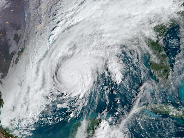
Hurricane Zeta was speeding toward storm-weary Louisiana with landfall expected Wednesday afternoon just south of New Orleans, where a pump system failure has raised the city's risk of floods. Life-threatening storm surge and strong winds were expected beginning around midday along the U.S. Gulf Coast, where residents were bracing for the 27th named storm of a historically busy Atlantic hurricane season.
Louisiana has had the worst of it, already hit by two tropical storms and two hurricanes. New Orleans has been in the warning area for potential tropical cyclones seven times this year, each one veering to the east or west.
"I don't think we're going to be as lucky with this one," city emergency director Colin Arnold said.
As Zeta approached, New Orleans officials announced that a turbine that generates power to the city's aging drainage pump system broke down on Sunday, with no quick repair in sight. There was enough power to keep the pumps operating if needed, but little excess power to tap if other turbines fail, officials said at a news conference with Mayor LaToya Cantrell.
Officials said they were running through contingencies to provide power and make repairs where needed should there be other equipment problems. Forecasts called for anywhere from 2 to 6 inches of rain in the New Orleans area, but Zeta is expected to be a relatively fast-moving storm, possibly mitigating the flood threat.
Zeta may have top winds of 100 mph by the time it makes landfall, CBS News meteorologist and climate specialist Jeff Berardelli reported on "CBS This Morning." In Mississippi, coastal cities Biloxi, Gulfport and Waveland may see wind gusts of over 100 mph and as much as 6-9 feet of storm surge, Berardelli reported.
Zeta raked across Mexico's Yucatan Peninsula on Tuesday, weakening to a tropical storm over land before strengthening again over the Gulf of Mexico. It's following a path not too different from Hurricane Laura, which was blamed for at least 27 Louisiana deaths after it struck in August, and Hurricane Delta, which exacerbated Laura's damage in the same area just weeks later.
Early Wednesday, Zeta's top winds grew to 90 mph and its forward movement increased to 17 mph as its center moved north, about 265 miles southwest of the mouth of the Mississippi River and about 295 miles south-southwest of New Orleans.
Hurricane warnings stretched from Morgan City, Louisiana, to the Alabama-Mississippi state line, including Lake Pontchartrain and metropolitan New Orleans. Tropical storm warnings were in effect for the western Florida Panhandle, forcing early-voting sites to close for hours in three counties where Republicans dominate.
The center of Zeta should make landfall in southeastern Louisiana in the afternoon, then move over Mississippi in the evening before crossing the southeastern and eastern United States on Thursday, the hurricane center said.
Louisiana Governor John Bel Edwards asked President Trump for a disaster declaration ahead of the storm. He and Alabama Governor Kay Ivey both declared emergencies, as did Mayor Andrew "FoFo" Gilich in Biloxi. Mr. Trump declared an emergency for Louisiana on Tuesday evening.
"There's no doubt that we've seen a lot this year, with COVID and so many threats from so many storms," Gilich said in a news release, "but this storm shows that we haven't seen it all yet."
Zeta broke the previous record for a 27th named Atlantic storm, taking shape more than a month before that one on November 29, 2005. It's also this season's 11th hurricane. An average season sees six hurricanes and 12 named storms.
The extraordinarily busy hurricane season has focused attention on the role of climate change, which scientists say is causing wetter, stronger and more destructive storms.
With yet another storm approaching, worries accumulated for people left homeless. The state is sheltering about 3,600 evacuees from Laura and Delta, most in New Orleans area hotels.
"I'm physically and mentally tired," a distraught Yolanda Lockett of Lake Charles said, standing outside a New Orleans hotel.
Meanwhile, many along the coast renewed an unwanted ritual of preparation.
On Dauphin Island, off the Alabama coast, workers at Dauphin Island Marina prepared for Zeta, although in some places there was little left to protect after Hurricane Sally hit in September.
"We don't have any docks or fuel pumps at this point. Sally took it all out," employee Jess Dwaileebe said.
In Louisiana's coastal St. Bernard Parish, east of New Orleans, Robert Campo readied his marina for another onslaught. "We're down for four or five days, that's four or five days nobody's fishing. That's four or five days nobody is shrimping. That's four or five days, no economic wheels are turning," he said.
"I've never seen anything like it," said Thomas Hymel, an extension agent in Jeanerette with the LSU Agricultural Center. He said the storms have meant more than a month of down time for seafood harvesters, many of whom are already suffering a drop in demand from restaurants due to the coronavirus pandemic.