L.A. fire maps show Palisades, Eaton, Hughes and more fires in California right now


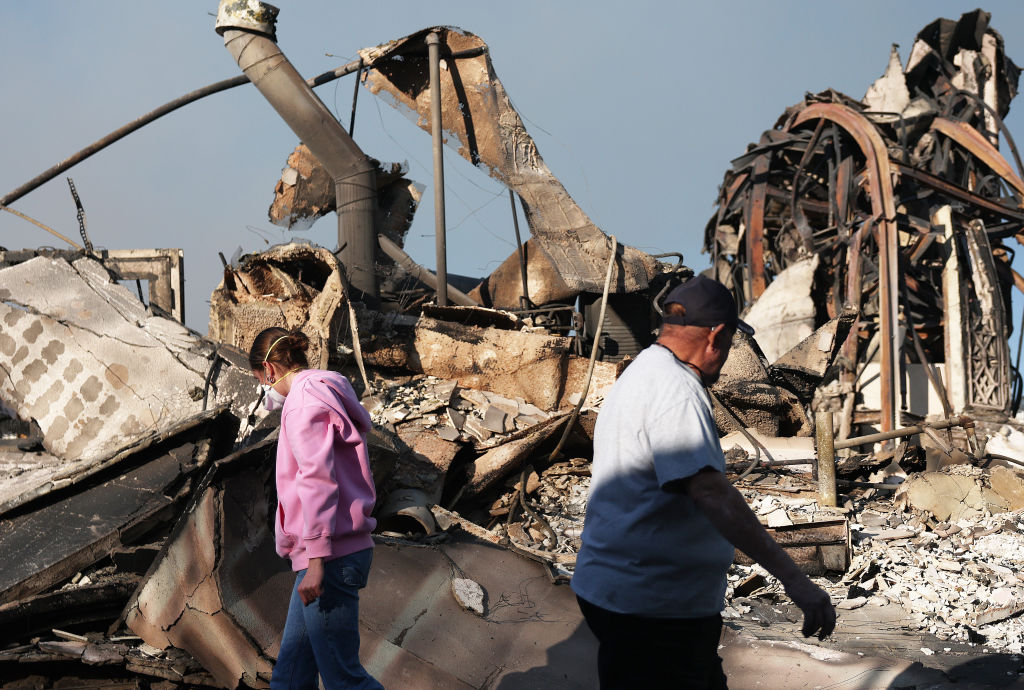
Firefighting and recovery efforts continue in the Los Angeles area, where devastating fires have killing at least 29 people, destroyed more than 12,000 structures and prompted evacuation orders for as many as 200,000 residents who hurried to escape the flames. Maps of Southern California show where the Palisades Fire, Eaton Fire, the Hughes Fire near Castaic, and several other blazes have scorched tens of thousands of acres.
Updating map of Southern California fires
An updating map created by CBS News' data team charts the expanse of the wildfires across Southern California.
The Hughes Fire, which erupted in northwest L.A. County on Wednesday, Jan. 22, spread to more than 10,000 acres and prompted evacuation orders and warnings for 50,000 people as high winds fanned the flames.
The Palisades Fire — the largest wildfire in the region — has burned more than 23,700 acres since it broke out the morning of Tuesday, Jan. 7, in the affluent Pacific Palisades neighborhood of Los Angeles. It grew out of a brush fire that exploded as powerful winds ripped through the area. Residents are now being allowed back into the devastated area, with proof of residency, to see what happened to their homes.
Firefighters have also been battling the Eaton Fire, which trails the Palisades Fire in size and has consumed more than 14,100 acres in northern Los Angeles County. Like the Palisades Fire, it expanded dramatically amid fierce winds on Wednesday, Jan. 8.
The Sunset Fire broke out the evening of Jan. 8 in the Runyon Canyon area of the Hollywood Hills, forcing a new set of evacuations. It had burned dozens of acres of vegetation, officials said.
Crews also battled the Hurst and Kennedy fires in the San Fernando Valley, and the Woodley Fire, in a Los Angeles nature reserve, which were brought under full containment.
Where are the Los Angeles fire evacuation zones?
Since the fire broke out, more than 200,000 residents of Los Angeles County have been ordered to evacuate their homes, with the Palisades Fire alone accounting for a substantial portion of those evacuations. Tens of thousands of others were under evacuation warnings. New evacuations were ordered for the Hughes Fire on Wednesday, Jan. 22.
Maps published by the California Department of Forestry and Fire Protection, known as Cal Fire, delineate areas where evacuation orders and warnings are in place. Mandatory evacuation orders are shown in red and warnings are shown in yellow.
Vice President Kamala Harris' spokesperson confirmed that her family's Los Angeles home was included in one of the evacuation orders.
The Palisades and Eaton Fires have spurred the most substantial evacuations. Photos and video taken in both areas capture harrowing scenes of smoke billowing up into the sky and structures swallowed by flames.
The Hurst Fire, which originated in the Sylmar neighborhood of Los Angeles late on Jan. 7, prompted additional evacuations as it spread, though it has since been contained.
The Sunset Fire on Jan. 8 prompted evacuations in the Hollywood Hills area between Laurel Canyon Drive and Mulholland Boulevard near the popular hiking spot Runyon Canyon, but it has also been fully contained.
Cal Fire is continuing to update comprehensive lists of evacuation zones in the incident reports for each active wildfire on its website.
Where did the Los Angeles fires start?
The Palisades Fire initially erupted Jan. 7 near Pacific Palisades, a partly coastal residential area in northwestern Los Angeles. It began as a brush fire near the site where an earlier fire, called the Lachman Fire, had been located on Jan. 1, and it spiraled out of control as high winds hit the region.
Sheila Kelliher, a Los Angeles County Fire Department captain, told "CBS Mornings" the following morning that fighting the wildfires was "incredibly challenging and volatile and unpredictable," calling the winds "ferocious" while imploring people in evacuation zones to heed officials' instructions and "get out when those warnings come."
"Pack up, get ready to go," Kelliher said. Referencing the pedestrians who abandoned their cars on roadways blocked by traffic when evacuations got underway, she added: "Sometimes, as you can see, the cars had to be left behind and a lot of times just even getting out on foot, you've got to get going."