Canadian wildfire smoke brings hazy skies, air quality alerts for Minnesota


The Minnesota Pollution Control Agency has issued a statewide air quality alert, including all tribal nations, that will be in effect through 6 p.m. Monday due to smoke from the raging wildfires in Canada's Manitoba and Saskatchewan provinces.
The agency says the hazy invasion is being aided by a cold front sweeping southward.
"Air quality is expected to reach the red AQI category in northern Minnesota, which is unhealthy for everyone. The rest of the state will reach the orange AQI category, which is unhealthy for sensitive groups," the agency said.
The entire state of Wisconsin is also under an air quality alert until 6 a.m. Saturday, but that could be extended.
Minnesota is expected to see the highest smoke concentration on Saturday morning and afternoon, with conditions briefly improving overnight Sunday before another wave rolls in.
"Air quality may improve Sunday evening before a third round of smoke arrives Monday," the agency said. "This air quality alert may need to be extended as additional waves of smoke will be possible."
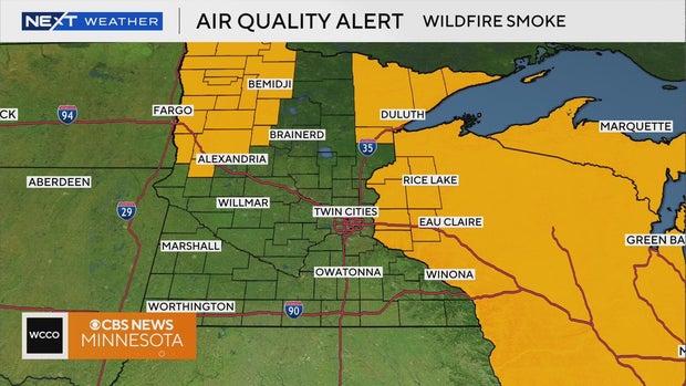
Areas in the red, or unhealthy, category include: Brainerd; Bemidji; East Grand Forks; Moorhead; International Falls; Two Harbors; Hibbing; Ely; Duluth; Roseau and the Tribal Nations of Leech Lake, Red Lake, Grand Portage and Fond du Lac.
"In the red area, everyone should limit prolonged or heavy exertion and time spent outdoors," the agency said.
Areas in the orange category, described as "unhealthy for sensitive groups," include: the Twin Cities metro; Alexandria; Albert Lea; Marshall; Worthington; Rochester; Hinckley; St. Cloud; Winona; Ortonville; Mankato and the Tribal Nations of Upper Sioux, Mille Lacs and Prairie Island.
The U.S. Environmental Protection Agency defines sensitive groups as "people with heart or lung disease, older adults and children."
Aside from the hazy, Friday will be sunnier and warmer with highs in the low 80s. Temperatures continue to climb, with highs back into the 80s on Saturday with some spots hitting 90 degrees on Sunday and Monday.
Tuesday is when the Twin Cities' next rain maker returns, with some soaking rains likely lasting into Wednesday, along with breezy winds dropping temps back into the 70s. Expect somewhere between 1 inch to 1.5 inches of precipitation.


