Strong thunderstorms possible Monday in Metro Detroit; higher risk of severe weather on Tuesday


Warm, springlike temperatures are surging into Southeast Michigan on Monday. Those conditions are helping to fuel a marginal (level 1/5) risk of severe weather issued by the National Weather Service for Metro Detroit, as there is expected to be enough instability for scattered thunderstorms to briefly become strong.
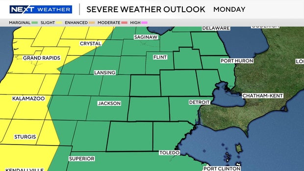
The primary threats for Monday are isolated damaging wind gusts and hail, with a very low-end tornado risk not completely ruled out.
By Tuesday, a stronger storm system and better wind dynamics will overspread the region, bringing a slight (level 2/5) risk for severe weather to Southeast Michigan, along with a more organized round of storms. This setup supports damaging winds, large hail, and the potential for a few tornadoes, especially as storms intensify later in the day and evening.
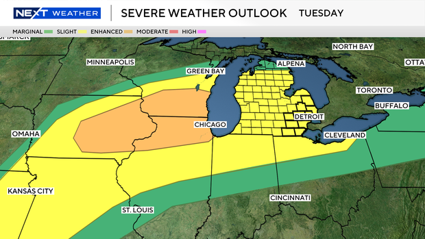
The CBS News Detroit weather team has declared Tuesday a NEXT Weather Alert day because of the possibility of severe weather.
The 2026 severe weather season started early in Michigan with a tornado outbreak on March 6. There was also a tornado confirmed in Belleville from the April 4 storms.
Michigan saw one of its most-active tornado seasons on record during 2025, with 33 tornadoes confirmed in the state that year.
Stay informed with CBS News Detroit
If there is a storm warning issued, the CBS News Detroit weather team will be livetracking the storm. You can follow the reports on air, online, on our mobile app and on our social media accounts such as YouTube .
If you wish to share photos or videos after a storm passes through, please join our Weather Watcher Network .