
Persistent "Nuisance" Storm
Winter Weather advisory is in effect from 3 PM until Sunday night through midnight. Even though this Saturday is getting off to a calm quiet start...once the flakes start to fly they will be around a while.
Watch CBS News
Winter Weather advisory is in effect from 3 PM until Sunday night through midnight. Even though this Saturday is getting off to a calm quiet start...once the flakes start to fly they will be around a while.

What looked like such a slam dunk forecast a few days ago has become an absolute head scratcher. Honestly, this storm could end up being a bust.

This storm will be very different from the last two, mainly because it will be a warmer storm.

This pattern looks as though it will continue for at least one more week as we are eyeing what might be yet another plowable snowfall this weekend.
Temps this morning in the teens are feeling below zero as winds continue to gust between 30-40 mph. It will be a harsh cold out there even with the sunshine. Highs will climb into the upper 20's and lwr 30's by afternoon. wind chills will still be in the teens. As the storm continue to pull away, I expect the winds to really begin to die down by evening with mostly clear skies.
Most roads and pavements will remain wet so traveling will not be an issue today. These morning bands of snow are part of an Arctic front which is breaking down the unseasonal warmth from Friday. Once this front pushes off the coast, we will wait for round #2 to come up the coast. How far this front pushes off shore could help to determine the how close this next storm will track to New England.

We had a close encounter with an asteroid Friday afternoon. Sort of.

Watch WBZ-TV reporters out in the field Saturday during the blizzard of 2013.

Watch WBZ-TV reporters out in the field Friday during the blizzard of 2013.

Clearly this is not a storm to be taken lightly. If you have not already completed your storm preparations you should do so immediately.

You say the words "Blizzard of 78" anywhere in Massachusetts, and even 35 years later, you hear the stories.
Skies have cleared across NNE, with more in the way of clouds in SNE...especially at the coast. Brighter skies will be found inland today with highs in the lwr-mid 30's with light Northerly winds...supplying the colder dry air from the north.

We are in for one heck of a ride in the next 24-48 hours, the classic New England-style roller coaster complete with warnings signs and all.
Once the front passes through by midday, the warm up will be on! SW breezes will pick up, clouds will begin to lift and even break! Highs will be climbing well into the 50's in SNE for a pretty nice afternoon despite the abundant cloud cover in place. A few scattered showers may try to peel off and start to move through during the early evening hours. Temps will continue to warm with breezy SW flow right through the evening where temps will likely reach 60 degrees and hold there until the cold front passes.
High pressure to our north is supplying cold dry air at the surface with a light North wind. The cold heavy air will be slow to depart. Low clouds are locked in place thanks to an inversion with warmer air aloft overriding this colder air at the surface. A warm front stalled to our south and will remain there all day helping to keep light NNE winds in place for most of the day. Northern New England has a better day with more abundant breaks of sunshine...away from the warm front. In fact, many northern ski areas have a new 4-6" of snow making for a great ski day! Under mostly cloudy skies, highs will take most of the day to climb into the mid 30's.
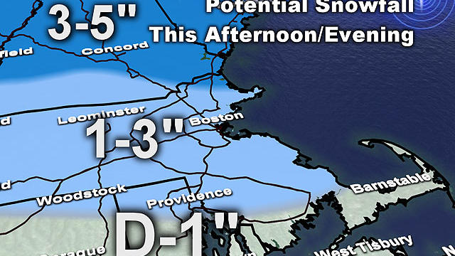
A second wave of precipitation will likely keep roads a bit hazardous piling some ice on top of the fresh snow.
Our Monday will start of dry..even with a little early morning sun. Any sun will quickly fade with a thickening overcast which will overspread the region. Snow will begin to push into Western New England by late morning and quickly overspread the region by afternoon.
Saturday is a bright sunny and cold day. Temps starting in the single digits and teens will eventually climb into the lwr-mid 20's by afternoon. Watching an energized short wave spilling in from the Great Lakes this afternoon which will provide enough lift to make for a few afternoon clouds and skies becoming partly sunny. Winds will pick up from the NW with this approaching shortwave and make for a wind chill factor in the single digits and teens.
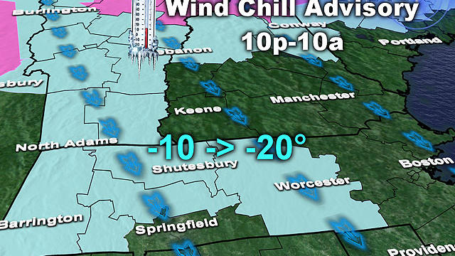
There will be a biting, gusty wind for most of tonight and again tomorrow night, producing wind chill values near 20 below in the northern and western burbs.
At this point, two coastal spots seem most likely to be affected - first, the seacoast of southern New Hampshire down to Cape Ann and second, the South Shore down to Cape Cod
It is an extremely complex set up with a high risk of a bust potential...from not much snow at all...to more snow than we were expecting. Here we will try to spell out our early thinking. This forecast will be evolving with each model run until Tuesday...where will likely be in full out nowcasting mode. Let's get to it!

Want a healthier alternative to chicken wings and nachos?
Winds are picking up from the SW with gusts to 30-50! A blustery windy day. Temps will be able to climb in to the mid-upper 40's in eastern MA along the coastal plain by the afternoon with skies at least becoming partly sunny..especially south of th Pike. Wind advisory for the Cape and islands where SW winds will gust 40-50 from midday through the afternoon. Across northern New England there are more clouds which will help to keep temps cooler today in the 30's and Lwr 40's

By rush hour it should be snowing just about everywhere with a rain/snow mix along the immediate coastline.
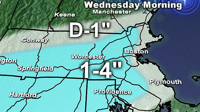
Don't be fooled, this winter is a very LONG way from being over. In fact, I believe the coldest and snowiest days are yet to come.