A January Delight...
After a cold start, temperatures will be climbing into the 30's and Lwr 40's this afternoon with partly sunny skies across SNE. Meanwhile, across the North...clouds will remain for most of the day...with breaks of sun in SNH.
Watch CBS News
After a cold start, temperatures will be climbing into the 30's and Lwr 40's this afternoon with partly sunny skies across SNE. Meanwhile, across the North...clouds will remain for most of the day...with breaks of sun in SNH.
Mostly sunny skies for most with highs in the mid-upper 30's by early afternoon. These temps will be falling off by the later part of the day as colder air settles in for the evening hours under clear skies. Another cold night with lows dropping into the lwr-mid 20's.
If one thing comes to mind about 2012...it is the warmth! Here is a look back in the year of weather that was.

Our first winter storm is upon us across eastern Mass.
Light snow will begin as early as later this morning/midday across the region. Little accumulation is expected during the daylight hours, perhaps a coating to an inch or so. Even a wet mix with right at the coast. The intensity will pick up in a big way by sunset heading into this evening after 6pm...snowfall rates could exceed an inch an hour between 7pm and 1am tonight. Then just as quickly as it started, it will taper off a few hours before sunrise on Sunday.
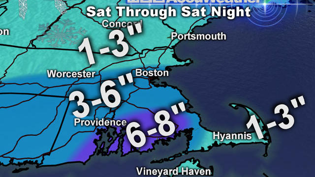
Some of our latest weather models are projecting the Saturday storm to be a bit juicier and taking a path slightly closer to the coast of Massachusetts.

Models have had a difficult time thus far nailing down a track for this one, but at this point I see two potential scenarios for Saturday.

The first flakes should begin to fly by sunset. Snow will begin to fill in rapidly by Wednesday night.
Wednesday will start of dry, cold and sunny...but clouds will be quickly advancing during the afternoon. Highs will remain in the lwr-mid 30's with light NE winds. Skies will be turning mostly cloudy by afternoon. The first flakes should begin to fly by sunset.
Winter weather advisory until 10 AM south of the MA Pike for this light snow to light frz rain/drizzle in the first few early morning hours, so avoiding travel at this time is your best bet...which should not be a problem. As we have said over and over..we are expecting a general 1-2" snowfall for most locations away from the coast, maybe a coating closer to the coast..

Latest information today for the Christmas Eve-Christmas morning snow looks a bit weaker than the morning runs. Light snow should begin around 8 PM, with a steady light snow for Christmas morning.

A wind advisory is in place across SNE from 1 PM to 11 PM for gusty winds to wrap in behind this departing low from the West. Wind gust to 40-45 mph will happen into the evening with clearing skies and temperatures dropping with a rush of colder air settling in for the evening. Temps will drop into the lwr-mid 20's overnight with blustery winds which will diminish slightly overnight.
Heavy Rain will be pushing from west to east this morning. The peak of the heavy rain will be in western New England this morning and be in place across Eastern MA and NH around noon through early afternoon. The heavy rain will produce about an 1" in most locations, enough to produce a little localized street flooding in the brief downpours...with maybe even an embedded thunderstorm

The most popular question to our weather team lately - "Is there any chance of a white Christmas?"
Bright sunshine for Saturday with light NNE winds with highs climbing into the mid-upper 30's.

Dry high pressure to our north will give us some morning sunshine, but it will be fading behind increasing high -mid level clouds during the day. Highs will climb into the 40's to near 50 in many areas this afternoon under partly sunny skies. Skies will end up being brighter across the north, with more in the way of clouds streaming through SNE thanks to a batch of showers just off our South coast. Winds will shift to the NE this afternoon then to the SE tonight as clouds will continue to thicken with an approaching warm front.

After midnight towards daybreak I expect the rain to become most steady with the warm front directly over southern New England at the crack of dawn. Morning showers will linger through the late morning along the coast. Showers will be mainly over by afternoon. NNW winds will lock in low clouds and a cool feel especially north and NW of Boston where highs will only be in the 30's and Lwr 40's. South of Boston highs will climb into the mid -upper 40's with the passage of the warm front in the afternoon.
A snowy, wintry start to the day with a widespread coating of snow. Temperatures will rise slowly today as highs slowly creep into the middle and then upper 30's be evening, turning any leftover snow showers to rain or drizzle for many.
A nice, but cool start to the week with sunny to partly sunny skies today. Temperatures have started off near 32 and will be climbing into the lwr to mid 40's this afternoon with a lighter westerly wind.

Our forecast will be complete with all the standard "ifs" "ands" and "buts" that all the others have, BUT we like to think that our forecast has an excellent chance of being accurate IF the atmosphere cooperates AND unfolds as we think it might.