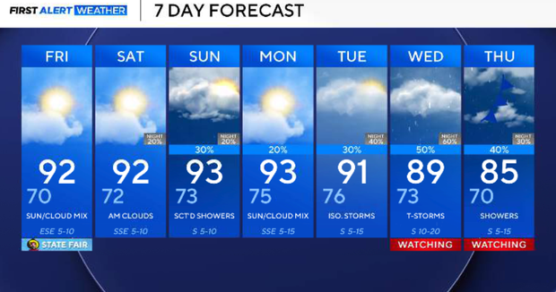
Slim chance of rain, storms for North Texas ahead of State Fair of Texas opening weekend


A few isolated showers and thunderstorms remain possible Thursday afternoon, mainly across western North Texas. Most of the metroplex stays dry.
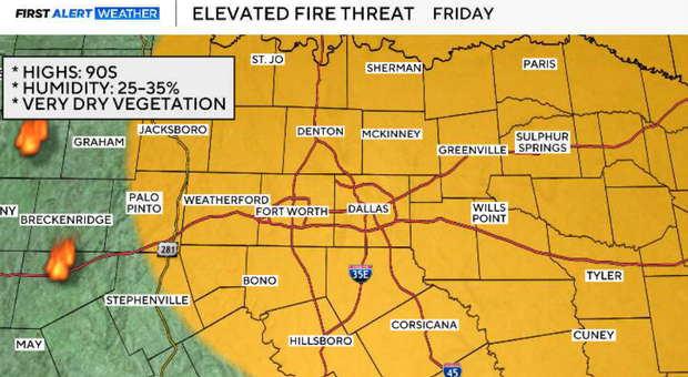
Friday turns even drier, with relative humidity falling to around 25–35%. Combined with the ongoing drought and dry vegetation, this will increase the grass-fire threat despite relatively light winds.
The upper-level ridge begins to retreat this weekend, allowing moisture to return and opening the door for increasing storm opportunities beginning late Saturday night into Sunday.
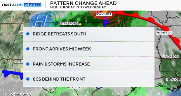
The larger change arrives next week. Guidance remains in fairly good agreement on a more amplified pattern that should finally send a decent fall cold front through North Texas around the middle of next week. Rain and thunderstorms should accompany the front, followed by highs potentially dropping into the 80s and lows into the 60s during the second half of next week.
Thursday evening is hot with highs in the mid to upper 90s. A few isolated showers or thunderstorms may develop, primarily across our western areas. Coverage will remain quite low, and most of North Texas will stay dry. Anything that manages to develop will be short-lived, but could produce gusty downburst winds, brief heavy rain and lightning. Activity should quickly fade around sunset.
Quiet and mild conditions return Thursday night. Skies will be generally quiet with overnight lows in the 70s.
Friday: State Fair opening day
The State Fair of Texas opens Friday, and we're looking at a hot, dry opening day. Highs climb into the low to mid-90s, but a significant push of drier air will make it feel less humid. Relative humidity during the afternoon could fall into the 25–35% range. That dry air combined with drought conditions and very dry vegetation will create an elevated fire threat across much of North Texas. Even with relatively light easterly winds, any sparks could ignite dry grasses.
Rain chances increase this weekend
Saturday, the ridge begins retreating south as a disturbance crosses the Central Plains. Southerly winds return, allowing moisture to gradually increase again. Saturday remains hot with highs in the mid to upper 90s. Most of the day should stay dry, although weakening convection from West Texas could approach our northwestern counties.
Sunday is when our rain chances become more interesting.
A cluster of storms developing upstream Saturday night could approach parts of North Texas Sunday morning. Any storms that survive could also send outflow boundaries southward, providing a focus for additional isolated to scattered thunderstorms Sunday afternoon as daytime heating increases. Not everyone will receive rain, but Sunday offers a better opportunity than we've had through the latter part of the workweek. Despite additional clouds and storm chances, temperatures remain above normal, with highs generally in the low to mid-90s.
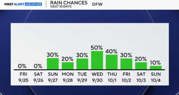
The overall pattern becomes increasingly active during the first half of next week as the western trough deepens and the persistent ridge loses its grip on North Texas. Rain opportunities will continue to increase as moisture builds ahead of the approaching system. Exact timing and coverage will depend on how quickly the larger trough and front progress eastward.
Rain and thunderstorms possible mid-next week
This continues to look like our most meaningful pattern change in quite some time. A more amplified upper-level pattern should finally allow a stronger cold front to push through North Texas around the middle of next week. This could be the first decent frontal passage of the season.
The front should provide a more widespread opportunity for rain and thunderstorms, followed by a noticeably different air mass. Ensemble guidance currently supports temperatures returning close to seasonal normals during the second half of next week, with highs in the 80s and lows in the 60s. There is still uncertainty regarding the exact timing and strength of the front, but confidence is increasing in a meaningful change from our persistent September heat.