North Texas still feels like summer the first full day of fall ahead of possible scattered rain


The main story remains the persistent September heat, but there are signs of a meaningful shift in the pattern ahead.
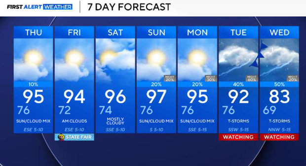
Temperatures stay well above normal through the weekend, with highs generally in the mid to upper 90s. A few isolated showers or thunderstorms remain possible Wednesday afternoon and again across western and southwestern North Texas. Most of the area, including the metroplex, stays dry.
The upper-level ridge begins to flatten this weekend, opening the door for a series of disturbances next week. Low rain chances return Sunday and Monday, followed by a better opportunity for more widespread rain Tuesday into Wednesday. That system could also bring northerly winds and lower temperatures, potentially giving us our first real taste of fall.
Wednesday evening, most of North Texas stays dry, but a weak boundary lingering across our western and southwestern counties could help spark a few isolated showers or thunderstorms through the late afternoon and early evening. Coverage will remain low, with the better opportunity well west of DFW. Any storm that develops should be short-lived, but could produce gusty downburst winds, brief heavy rain and lightning. Otherwise, it remains hot with highs generally in the mid to upper 90s.
Any isolated showers or storms should fade fairly quickly after sunset. The remainder of the night will be quiet and mild, with overnight temperatures generally in the 70s.
Thursday will look very similar to Wednesday. Highs once again climb into the mid to upper 90s, and most of North Texas remains dry. Another round of isolated afternoon showers or thunderstorms will be possible, primarily across our western counties, where the leftover boundary will still be lingering. Coverage remains low, so this is not a widespread rain event.
Friday: State Fair opening day
The State Fair of Texas opens Friday, and we're looking at a hot but relatively less humid opening day. Highs will generally reach the low to mid-90s. Easterly winds will help keep humidity in check, and rain is not expected. With temperatures still running well above normal, sunscreen and plenty of water will be important for anyone spending the day at Fair Park.
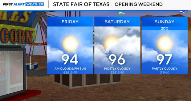
Saturday, the upper-level ridge begins to flatten as a trough deepens along the West Coast. That won't immediately bring relief, though. Southerly winds return Saturday, allowing warmer air and some additional moisture to move back into North Texas. Highs climb into the mid to upper 90s, with most of the area remaining dry.
Sunday and Monday
This is when we begin transitioning toward a more active pattern. The first in a series of upper-level disturbances moves across the central United States on Sunday. The strongest forcing should remain north of North Texas, but there will be enough moisture and instability for a few showers and thunderstorms Sunday into Monday. Rain coverage still looks relatively limited during this first part of the transition.
Showers and a cold front for North Texas next week?
This is becoming the most interesting portion of the forecast. A stronger and deeper upper-level disturbance is expected to approach the Southern Plains around the middle of next week. At the same time, moisture will increase across North Texas.
That combination should support a better and potentially more widespread opportunity for showers and thunderstorms Tuesday into Wednesday. A frontal boundary should also be involved with this system. The exact timing still needs to be refined, but northerly winds behind the boundary combined with clouds and rain should finally help bring temperatures down.
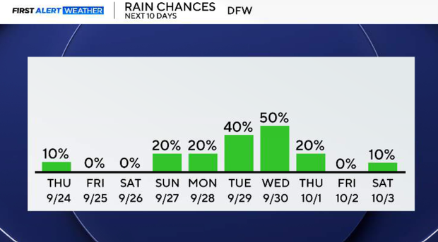
By the middle of next week, we could see temperatures move closer to late-September normals, which for DFW means highs in the upper 80s rather than the persistent mid- and upper-90s we've been experiencing.