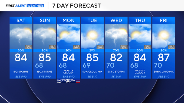
North Texas storm chances could damper outdoor plans for Memorial Day Weekend

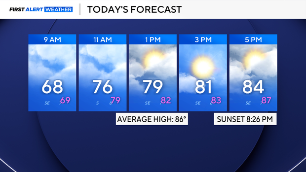
Saturday got off to a loud and rainy start in the morning as a line of thunderstorms moved across North Texas from 2 a.m. until 5 a.m. Gusty winds and hail quarter sized were reported in University Park, Grapevine, and Duncanville.
The system pushed eastward, allowing conditions to dry out for the rest of the morning into the early afternoon. However, another disturbance in the late afternoon will increase the chance for additional storms. As of now, no severe weather is expected, but lightning and flooding will stay a concern. The high today will be in the middle 80s. Expect cloudy skies turning mostly sunny by the afternoon.
For the rest of the Memorial Day Weekend, there will be additional chances of rain, cloudy skies, and temperatures in the 80s. For Sunday, expect the chance for afternoon showers and storms, especially for those along and to the east of I-35.
On Memorial Day there is a lower chance for storms, but it will still remain a possibility. Be sure to keep your eye to the sky during outdoor festivities. Lightning is extremely dangerous. If a storm is moving your way, head to shore and shelter immediately if out on the lake or swimming!
As for the rest of the week, more disturbances will impact North Texas, keeping the weather pattern active. More rain and storms will be likely, don't put up the umbrella yet. Stay tuned!