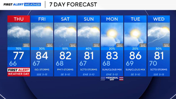
Temperatures top off in 70s before heavy rain moves back in Thursday, prompting flooding threat for North Texas


Expect plenty of clouds throughout Wednesday, with highs struggling to get out of the 70s. There is only a low 20% chance of a shower or rumble of thunder, mainly south and east of the Dallas-Fort Worth metroplex.
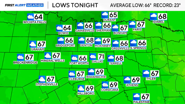
Wednesday night will be cloudy, muggy and rainy. We will see overnight lows dip into the mid-60's. A few rounds of rain will move through, but the morning commute looks decent.
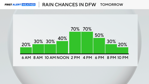
Thursday will be wet and we will see waves of rain and storms during the afternoon. Highs will stay in the mid-to-upper 70s to low 80s. The overall potential for severe weather is low, but heavy rainfall will be the primary concern.
During the morning commute, we're expecting a few scattered showers west of 35. Showers then move closer to the metroplex around lunchtime and continue during the afternoon and for part of the evening commute.
This will be scattered, heavy rain at times during the afternoon and evening.
These are non-severe thunderstorms, but will carry a heavy rain threat and a gusty wind threat that could be disruptive for evening commuters.
Memorial Day weekend will have highs in the 80s and a few stray showers and storm chances. The potential for severe storms is low, but we will see a few rain chances that could impact plans.
We will see a decent chance of rain and storms pretty much every day as we head into next week. The lawns will love this, and it will definitely help with the drought.