Temperatures to stay in 80s in North Texas after heavy rains earlier in the morning


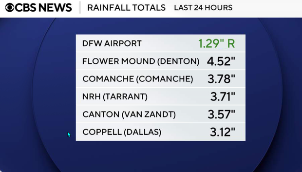
Monday began with showers and thunderstorms that dropped very heavy rainfall, leading to some flash flood warnings. We've since seen all warnings dropped for the area. Most of the region received 1-3 inches in the past 24 hours, but accumulations between 5-7 inches in Lewisville and the western portions of Fort Worth were recorded in the past 24 hours. Across the southern counties, accumulations ran high between 5 and 9 inches in some spots.
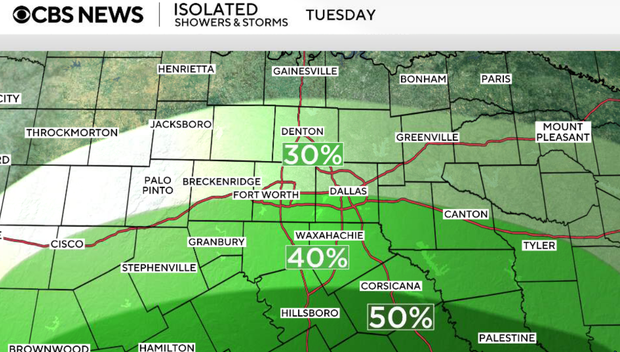
Scattered showers and thunderstorms will be possible the rest of Monday, but most of the area should begin to dry out into the overnight hours, with a lingering 20% chance of rain Monday night into Tuesday morning. Latest data suggests that most of the rain should stay along and south of the I-20 corridor.
Most of North Texas will remain under a level 2/4 risk of flash flooding into Tuesday, as rain chances resume in the afternoon at 40%, with the highest chances of rain between 4-10 p.m.
These storms will once again be slow-moving and produce heavy rainfall where they do develop, but coverage should be less than Monday. Regardless, it won't take much rain to fall to cause some issues, especially in areas that received the highest accumulations this morning.
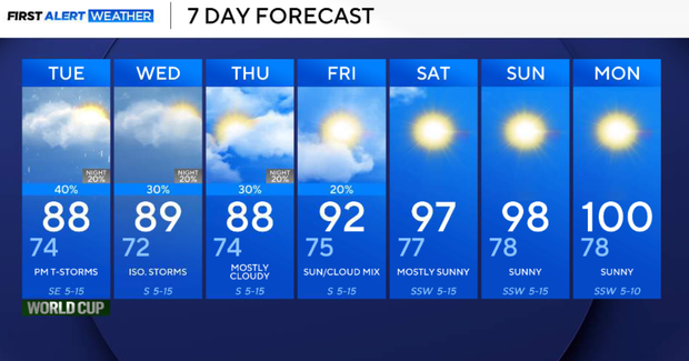
Temperatures will remain in the upper-80s to lower 90s through Thursday.
Rain chances on Thursday decrease to 20% as a ridge of high pressure begins to build into the area from the east, ending rain chances Friday into the weekend.
With rain chances ending by Friday, we resume the hot and sunny conditions, typical of July, with temperatures warming back into the upper-90s and 100°F by the start of the following work week.