Hot, humid weekend ahead for North Texas before storm chances return

The First Alert Weather team is watching an increasingly active weather pattern late this weekend and into next week.
While rain chances stay fairly low through Sunday, storm coverage looks to increase Monday and Tuesday, with some storms potentially becoming strong to severe. Early rainfall projections suggest some areas could pick up 1 to 2 inches, especially east of I-35 where drought conditions remain more significant.
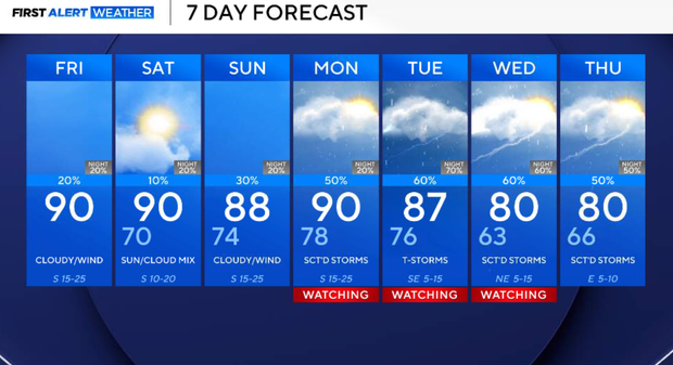
Friday will be warm and windy with increasing humidity. Highs will climb into the upper 80s to low 90s across North Texas, with Dallas/Fort Worth near 90. Winds from the south will gust from 20 mph to upwards of 30 mph in the afternoon.
A disturbance moving across Texas may trigger a few isolated showers or a stray thunderstorm in the late afternoon and into the evening, but coverage remains low, around 20%, and most areas should stay dry. A strong cap should limit storm development, so any activity will remain isolated and below severe limits.
Friday night will be warm, breezy and muggy with lows near 70. A stray shower or storm can't be ruled out early, but it will otherwise quiet overnight.
Saturday will likely the quietest day of the weekend, warm, breezy and humid with highs in the upper 80s to near 90. A strong cap and dryline staying well west should keep most, if not all, of North Texas dry.
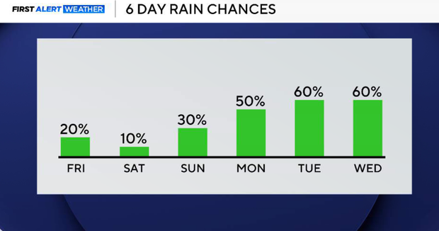
On Sunday storm chances begin increase by the late afternoon and evening, especially north and west of the Metroplex. Coverage still looks fairly isolated, but a few stronger storms cannot be ruled out.
By Monday, storm coverage increases. Scattered showers and thunderstorms become more likely as a more active pattern develops. Temperatures remain warm, near 90, with increasing humidity.
Tuesday is the best chance for widespread rain and thunderstorms. A front approaching from the northwest should help increase storm coverage across North Texas. Some storms could become strong with hail and gusty winds possible.
Rain chances may linger depending on how quickly the front moves through, with somewhat cooler temperatures possible by midweek.