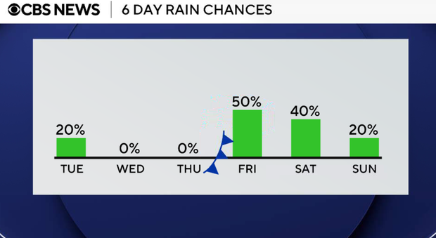
Rain chances decrease as temperatures rise in North Texas


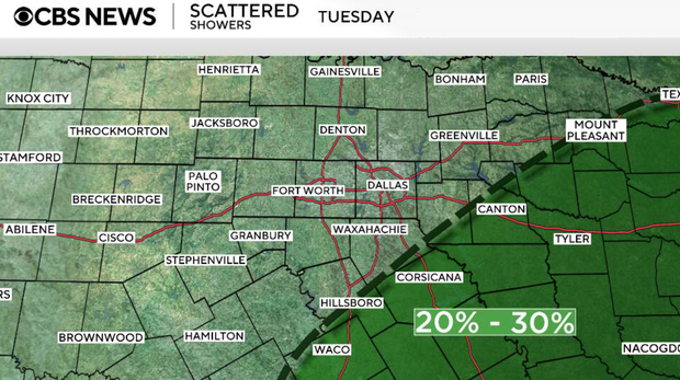
A coastal low will continue pulling moisture northward into Texas through Tuesday before gradually shifting away. As that occurs, rain chances will decrease, and temperatures will begin climbing again.
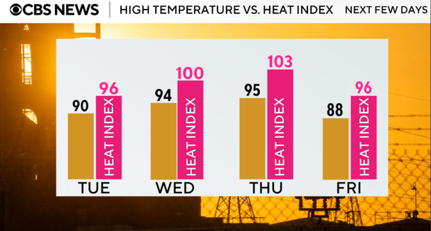
The bigger weather story for North Texas will become the return of summer heat by the middle of the week. Highs will climb back into the mid to upper 90s on Wednesday and Thursday, with heat index values approaching or exceeding 100 degrees.
Another pattern change arrives late this week as a cold front approaches from the north. Rain and thunderstorm chances return Thursday night into Friday and may continue next weekend.
Monday evening, cloudy skies and isolated showers will continue at times, particularly across areas south and east of the metroplex.
Monday night, rain chances gradually decrease, although a few showers may linger east of I-35 and south of I-20. Lows will fall into the low 70s.
On Tuesday, a few lingering showers will remain possible east and southeast of the metroplex, but most of North Texas should begin drying out. Cloud cover will decrease through the day with highs returning to the upper 80s and lower 90s.
Wednesday will be mostly sunny, hot and humid. High temperatures will climb into the low to mid 90s with heat index values approaching 100 to 103 degrees.
On Thursday, summer-like conditions continue with highs in the mid to upper 90s. South winds and increasing humidity will push heat index values into the triple digits during the afternoon.
Late Thursday night, a cold front approaching from the north will begin increasing rain and thunderstorm chances.
Friday, scattered showers and thunderstorms are expected to develop along and ahead of the approaching front. Some storms could produce gusty winds, heavy rainfall, and frequent lightning.
Forecast confidence decreases somewhat heading into the weekend, but an unsettled pattern appears likely to continue. Additional rounds of showers and thunderstorms remain possible Saturday as disturbances move through the region. Sunday looks drier and a bit hotter with a high of 94F.