The hottest days of summer 2026 are here. Near-record temperatures expected for North Texas


This week is expected to be the hottest one of this summer so far for North Texas. The area will reach near-record highs on some days this week as well.
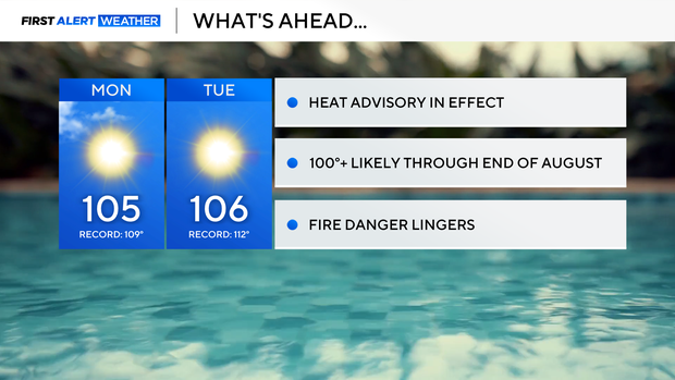
There's a heat advisory in place for Monday, mainly due to high temperatures. The humidity is lower, so feel-like temperatures won't be too far off from the actual temperatures. When the air is drier, it can heat up more, which is why temperatures are getting into the 105-106° territory this week.
The low humidity and dry conditions will not help the fire threat. Monday, DFW is under a high fire danger and is forecast to reach the very high category by Wednesday. This is something the First Alert Weather Team will keep a close eye on throughout the week.
Extreme heat warning for North Texas
A Heat Advisory is in effect for much of North Texas as actual temperatures climb well into the triple digits. Highs between 102° and 106° are expected Monday. Humidity will mix out considerably during the afternoon, so the heat index may not be dramatically higher than the actual temperature.
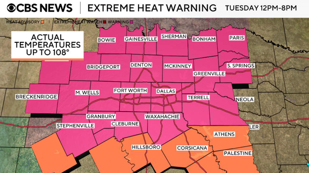
An extreme heat warning will then be in effect from noon until 8 p.m. on Tuesday, with actual air temperatures potentially reaching 108° in some locations. The extreme heat will significantly increase the risk of heat-related illness, especially for anyone spending extended time outdoors. We will emphasize limiting strenuous outdoor activity, staying hydrated, checking on vulnerable neighbors, and never leaving children or pets inside a vehicle.
We're watching a very low chance for an isolated shower near the Red River Monday, followed by our next slightly better rain opportunity with a weak front Friday.
A weak front will sag toward the Red River late Monday afternoon, but strong high pressure overhead and very dry air will make it difficult for storms to develop. There is only about a 10% chance for an isolated shower or storm near our far northern and northeastern counties. For nearly everyone else, the forecast remains completely dry.
Afternoon dew points will fall into the 50s in many locations, keeping the heat index fairly close to the actual temperature. That lower humidity may make the heat feel slightly less oppressive, but it also continues to dry out vegetation and contributes to the grass fire concern.
Any isolated activity near the Red River will fade quickly after sunset. Otherwise, expect a warm and dry night with lows ranging from the mid 70s outside the metroplex to the lower 80s in the urban core.
Tuesday
An extreme heat warning will be in effect from noon until 8 p.m. on Tuesday, with actual air temperatures potentially reaching 108° in some locations. Mostly sunny skies. Rain chances are essentially zero, with perhaps an extremely isolated shower well east or northeast of the metroplex. The good news is that afternoon humidity remains relatively low. The bad news is that actual temperatures will be among the hottest we've experienced this summer.
Wednesday and Thursday
Very little relief is expected through midweek. Highs remain around 104° to 106° Wednesday, followed by another triple-digit day Thursday. High pressure remains the dominant feature, suppressing clouds and meaningful rainfall. Low afternoon humidity will also continue to support an elevated grass fire threat, although relatively light winds should help limit rapid fire spread compared with some of the windier days we experienced last week.
Looking Ahead
A weak front may make another attempt to reach North Texas Friday. This front could bring a small chance for showers and thunderstorms, but it does not look capable of delivering meaningful relief from the heat. Even Friday could still reach around 102°. High pressure is then expected to strengthen again over the weekend, keeping temperatures above normal and returning highs into the 102° to 103° range or hotter.
There is currently no significant rainfall or meaningful cool-down showing up through at least the next seven days, and above-normal temperatures may continue through the end of the month.


