North Texas sees extreme heat warning for Tuesday afternoon amid triple-digit temperatures


An extreme heat warning is in effect through 8 p.m. Wednesday for much of North Texas. Actual temperatures will climb into the 105° to 108° range in some locations, creating dangerous conditions for anyone spending extended time outdoors.
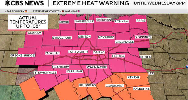
What we're watching
This is the most intense stretch of heat we've experienced in several weeks. Highs will reach around 105° to 108° on Tuesday, followed by another afternoon near 105° to 106° on Wednesday.
Despite relatively lower humidity during peak heating, these actual air temperatures alone are dangerous enough to cause heat-related illness. Anyone working outdoors should take frequent breaks in the shade or air conditioning, drink water regularly, and avoid the hottest part of the afternoon whenever possible.
We're also watching increasingly dry vegetation. Afternoon relative humidity will drop into the 20–30% range, supporting additional grass fire activity despite relatively light winds.
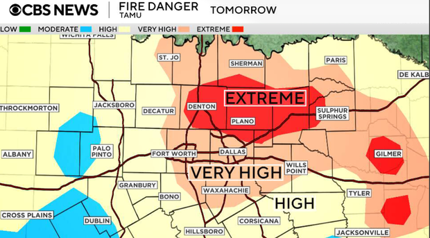
Tuesday afternoon and evening
Expect abundant sunshine with temperatures quickly climbing through the triple digits. Highs will range from around 100° to 108°, with DFW expected near 106°.
Afternoon dew points will mix down into the 50s and lower 60s, meaning the heat index will generally stay within a few degrees of the actual temperature. That does not make Tuesday's heat less dangerous. Anyone working or exercising in direct sunlight will experience even greater heat stress.
Winds remain relatively light, generally around 10 mph or less, which should help limit the rapid spread of wildfires. However, increasingly dry grasses and low humidity mean fires can still ignite easily.
Tuesday night
Another very warm night is ahead. Temperatures will only fall into the mid to upper 70s outside the metroplex, while many locations within DFW remain in the lower 80s through Wednesday morning.
Wednesday
Wednesday is another First Alert Weather Day. The extreme heat warning continues through 8 p.m., with highs once again around 104° to 108° across much of North Texas.
Mostly sunny skies and very little cloud cover will allow temperatures to rise quickly during the afternoon. Humidity will again decrease with daytime mixing, but actual temperatures remain dangerously hot.
Thursday
Triple-digit heat continues, with highs generally around 103° to 105°. The upper-level ridge begins shifting west, but the change will have very little immediate impact on temperatures.
Friday
A weak frontal boundary may reach North Texas late Friday into Saturday. There could be an isolated shower or thunderstorm, but current rain chances remain very low, around 10% for most areas. Even with the front nearby, highs are still expected to reach the low 100s. This is not expected to bring meaningful heat relief.
This weekend and ahead
High pressure quickly strengthens again over the weekend, keeping temperatures well above normal. Highs are expected to remain around 103° to 106° through the weekend and into early next week.
There is currently no meaningful rainfall or significant break from the heat showing up in the extended forecast. After more than a month without measurable rain at DFW, the continued dry pattern will also keep vegetation stressed and maintain concerns for grass fires.



