Maps show where winter storm threatens to bring heavy snow, ice, brutal cold this weekend
See the latest updates for Saturday, Jan. 24, here. Earlier forecasts are below.
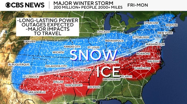
More than 200 million people across the United States are in the path of a major winter storm that's forecast to bring a mix of ice, snow and frigid conditions to a 2,000-mile expanse of the country through the weekend. About two-thirds of the U.S. could be affected by what will likely be the largest winter storm in at least five years.
Freezing rain, snow and rain started Friday in the Southern Plains before it was forecast to move into the Mississippi and Tennessee Valleys on Saturday and then head into the Northeast and Mid-Atlantic on Sunday into Monday.
The system is forecast to be slow-moving, meaning long durations of snow and ice will have time to accumulate.
Winter weather alerts continued to be issued from the Southern Plains across the South and into the Northeast through Monday, impacting at least 185 million people. Seventeen states and Washington, D.C., are under a state of emergency, and 35 states are expected to be affected by the storm. Nine states have activated National Guard troops.
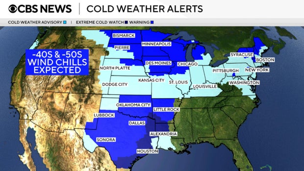
Extreme cold temperatures are also a major concern. Friday morning, thermometers in the Minneapolis area were at 21 degrees below zero, with wind chills even colder. Temperatures through the weekend are expected to sink to record lows across parts of the Southern Plains and Mid-Atlantic.
Maps show what to expect from the winter storm
A low-pressure system is forecast to develop in the Southwest and interact with incoming Gulf moisture and Arctic cold air. The system began dropping precipitation on Friday in the Southern Plains.
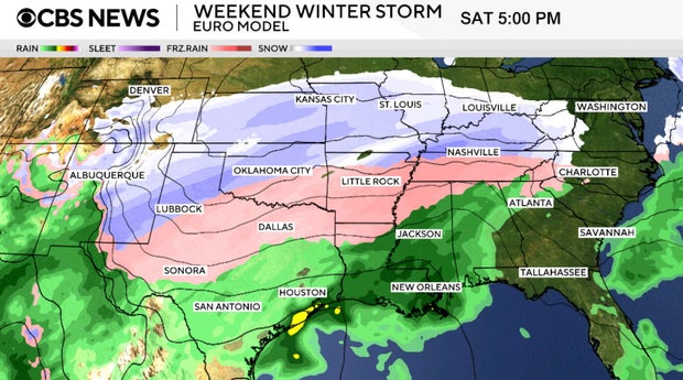
The system is expected to slowly move eastward, bringing snow and accumulating ice. Forecast models continue to change as the event nears, but it is set to impact broad swaths of the U.S., from Arizona to Maine, said National Weather Service meteorologists Rich Otto and Tony Fracasso, of the agency's Weather Prediction Center.
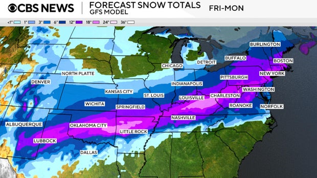
Heavy snow is expected over a wide band of the country, with a foot or more potentially headed for parts of the Texas Panhandle and the Ozarks, Otto and Fracasso told CBS News. The highest snowfall totals — possibly up to 2 feet — could accumulate in the central Appalachians and into the Northeast, they said.
According to CBS New York meteorologist Scott Padgett, some parts of New York could see anywhere from 6 to 12 inches of snow.
Meanwhile, the polar vortex that is usually situated over the North Pole is dipping down into the U.S., bringing unusually cold temperatures starting Thursday and lasting through the first half of next week. Extreme wind chills of more than 50 degrees below zero have been reported in parts Minnesota and North Dakota.
Communities from Texas, Arkansas and Oklahoma to Washington, D.C., and New York City could see records set for the coldest high temperatures. Frostbite can occur in as little as 5 to 10 minutes if exposed to this dangerous cold.
The harsh cold means snow and ice will linger on the ground well into the middle of the week after the storm passes.
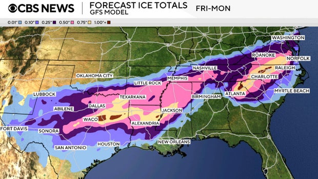
Ice is expected to accumulate along the southern side of the storm's track. Considering the storm's slow movement, the amount of accumulation is expected to be up to three-quarters of an inch or even an inch of ice in some areas. Impacts of this magnitude can bring down power lines. With the harsh cold in place, power outages could leave people freezing without indoor heat in some communities.
Parts of northeastern Texas, northern Mississippi and southwestern Tennessee will likely feel the most substantial effects of the ice, said Otto and Fracasso. They noted that icy conditions are also expected to have significant impacts on a block of the Southeast from northern Georgia into the Carolinas.
Possible snowfall amounts upwards of 12-18 inches could be seen from the Southern Plains up into the Northeast, but the expected totals are still in flux for individual locations as forecast models continue to come together.
As this system moves east, snowfall amounts will vary depending on location.
Winter storm may impact travel plans
Travel will be disrupted by weather conditions on roadways and at the airports. Some airports in the South do not have deicing equipment for aircraft to take off safely, possibly leading to widespread cancellations and delays over the weekend.
Some airports that could see issues are Dallas Fort Worth International Airport; Will Rogers International Airport in Oklahoma City; Clinton National Airport in Little Rock, Arkansas; Memphis International and Nashville International airports in Tennessee, and Hartsfield-Jackson Atlanta International Airport.
Major U.S. airlines are issuing travel waivers, and many carriers are issuing travel alerts and allowing customers to change their plans without penalty as of Thursday.
American Airlines, whose hub is Dallas Fort Worth International Airport, said it was adding 17 extra flights in and out of DFW on Friday, and Sunday to help the surge of travelers who were scrambling to make their trips. Eight of those were departing DFW on Friday, 17 on Saturday and nine would arrive at DFW on Sunday.
The airline also added another 17 flights on Saturday between Charlotte Douglas International Airport and Chicago O'Hare International Airport.
An analysis by CBS News found that at least 2,495 total flights on Saturday have been canceled across the U.S. so far.
In a news release Thursday evening, Delta Air Lines said it flight cancelations would be "necessary" at "select airports in North Texas, Oklahoma, Arkansas, Louisiana and Tennessee." It did not detail how many flights were expected to be impacted.
The roads could also become very difficult to navigate, if not impossible, with slick conditions on major interstates such as I-10, I-20, I-30, I-35, I-40, I-44, I-49 and I-55.
Travel on the roads is highly discouraged through the weekend, but if it's absolutely necessary, people are advised to drive with caution.
"Treacherous and hazardous driving conditions are likely due to both the ice and snow accumulations. In some areas, travel will become nearly impossible during the peak of the storm," said Otto and Fracasso. "The extreme cold that follows the storm will prolong the potential impacts, with many areas not getting above freezing for much of next week."
Officials urge drivers to consider taking a winter storm kit with them, including such items as booster cables, a flashlight, a shovel, blankets and extra clothing as well as water, a first aid kit and anything else that would help survive being stranded.
Preparations underway
About 18,000 utility workers have been pre-positioned in the Carolinas, while at Tennessee' State Emergency Operations Center, officials will monitor road conditions in real time.
Outside Oklahoma City, the Oklahoma National Guard is on standby to help stranded drivers and passengers. The city and state have less than 100 plows for more than 1,800 miles of roads.
New York City Mayor Zohran Mamdani said the city had "procured 700 million pounds of salt" in advance of the storm. Salt trucks were already out in force Friday, brining the streets and highways. More than 2,000 sanitation workers and 700 salt spreaders were being deployed in the operation.
"Every piece of equipment is fitted with a specific kind of high-tech GPS that lets us get real-time data from around the city," Joshua Goodman, a spokesperson with the New York City Department of Sanitation, told CBS News. Goodman said that will help officials know which parts of the city are being hit the hardest.
In Texas, heavy ice could weigh down power lines and trigger widespread outages. Texas Gov. Greg Abbott said in a news conference Thursday that Electric Reliability Council of Texas, which operates the state's power grid, "has never been stronger, never been more prepared, and is fully capable of handling this winter storm."
Texas transportation agencies are working overtime to prepare, with officials hoping to avoid a repeat of the widespread outages caused by a paralyzing ice storm in 2021 that led to the deaths of more than 200 people.
Stores throughout the South were packed with people loading up on supplies such as generators, flashlights and batteries. In the Fort Worth area, some shoppers were finding essential items out of stock.
Meanwhile, staffers at Rush University Medical Center in Chicago were preparing for a surge in cold-related trauma, with emergency room physicians on standby.
"We'll see a lot of patients for exposure, frostnip, frostbite, maybe some hypothermia," Dr. Scott Heinrich, a Rush ER physician, told CBS News. "We see our vulnerable populations, those that are housing insecure, maybe our older adults without heat."
Reasons for forecast uncertainty
After weather prediction models showed considerable variation in their winter storm forecasts earlier in the week, the uncertainty is decreasing as the storm's arrival nears.
Those variations seen earlier in the week were not unusual, said Otto and Fracasso, adding that there can be significant differences "among forecast models 3-4 days ahead of the start of a storm."
Predicting winter storms can carry an additional layer of uncertainty, as freezing temperatures create another variable in the forecast.
"For winter storms, the uncertainty is compounded due to the uncertainty in total precipitation amount in addition to the type of precipitation that may fall," said Otto and Fracasso. When the type of precipitation is snow, very slight atmospheric changes like temperature variations of just one or two degrees can alter the forecast dramatically, they added.