Snow, heavy rain and wind expected at various times this upcoming weekend

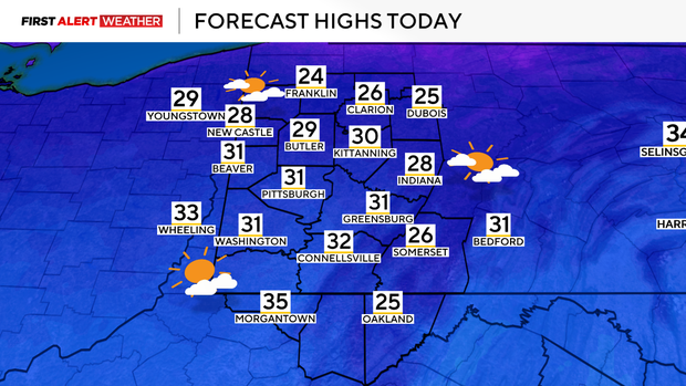
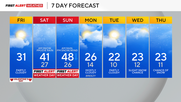
Friday morning begins with mostly cloudy skies and a few remnant flurries in the wake of last evening's fast-moving disturbance and cold front passage. Temperatures are in the teens to near 20 this morning and will rise into the lower 30s and upper 20s later today. This will be accompanied with partly cloudy skies, and winds will be much lighter thanks to an area of high pressure moving in and around the Pittsburgh area.
WEATHER LINKS:
Current Conditions | School Closings & Delays | Submit Your Weather Photos
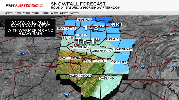
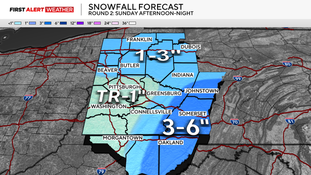
This high will quickly move to the east on Friday night as another powerful low pressure gears up to the southwest and moves toward the Ohio Valley and Lower Great Lakes by Saturday and Sunday. Precipitation types will vary this weekend, likely starting with snow Saturday morning, shifting to rain Saturday afternoon and night, then switching back to snow as the cold air moves in on Sunday afternoon. The snow on Saturday morning will mainly be prevalent from Pittsburgh north toward Route 422 and I-80. A quick 1-3 inches is possible, especially north of Route 422 toward I-80 because as precipitation falls into a dry layer, it will allow the air to cool and support snow making it down to the surface for a few hours. As warmer air moves in through the day, the Pittsburgh metro will transition to rain by midday and/or early afternoon and stay with on and on periods of rain through the afternoon and into Sunday morning. Areas north of Pittsburgh will also transition to rain, but likely a little later on Saturday.
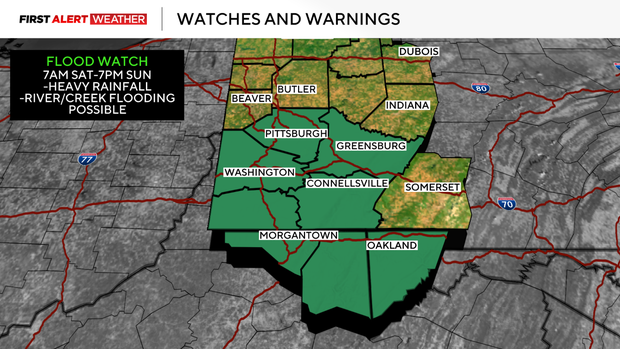
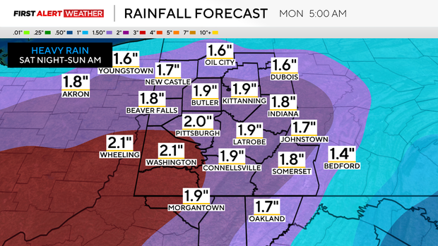
The latest trends with the model guidance show the low passing near or just northwest of Pittsburgh late Saturday night into Sunday morning, which is a bit more north than what was indicated yesterday. This makes sense given the configuration of this storm system and positioning of the jet stream winds aloft. This means the axis of heavy rain Saturday night into Sunday morning will likely be centered across Southwest Pennsylvania into Northern West Virginia and follow the Ohio River Southwest. A flood watch is in effect from Pittsburgh south through Washington and Westmoreland counties and into Northern West Virginia for the potential of runoff from 1-3 inches of rain which could lead to river and creek flooding. The rain will be heaviest between midnight and midday Sunday, before it shifts east through the day Sunday. Once the low pressure and its associated cold front move east, winds will pick up to 20mph-30mph, with higher gusts Sunday afternoon and evening. Temperatures will fall into the 20s in the evening with additional light-moderate snow expected. The heaviest snow with the second round will likely occur in the Laurel Highlands and Ridges, with westward facing slopes receiving 3-6 inches. As of now, the Pittsburgh metro and points southwest will see up to 1 inch and 1-3 inches will be possible between I-80 to Route 422. Adjustments to the forecast for the second round of snow on Sunday will be possible as high resolution models come in over the next 24 hours.
Behind Sunday night's system, well below average temperatures will settle in for the beginning of next week with highs in the low 20s and lows in the low teens. Another system may move toward our region by next Wednesday and Thursday with a chance for some snow.
Stay up to date with the KDKA Mobile App – which you can download here!


