Rain returns to the Pittsburgh area today with on and off showers throughout the day
Here comes the rain. Don't forget the umbrella today, with showers around for most of the day.
Any Alert Days Ahead? None.
Aware: Today's rain will break another double-digit days-long dry spell for the area.
At times, the rain will be scattered, with the best chance for rain and the highest rain rates occurring this afternoon from around 2 p.m. to 5 p.m.
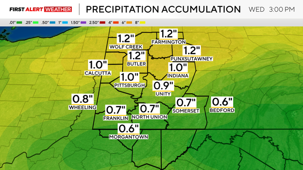
By the time this daily blog is posted, you've probably seen some rain with spotty off-and-on showers around during the morning. It looks like the steadiest morning rain will be along I-80. The steadiest afternoon rain will be between I-80 and I-70. Rain totals for most will be between 0.5" - 0.75".
There will likely be an isolated area that sees well over that, though, and flash flooding or even low-level areal flooding can't be ruled ou,t but the overall chance for that occurring is low.
The rain is due to a cold front that will move through overnight.
Rain chances will stick around through around 3 a.m. on Wednesday morning. Behind the front winds will pick up for the rest of the day. We may even see a wind advisory being issued for the Laurel Highlands, even though it looks like we will be JUST below guidelines right now.
I have winds gusting up to 40mph in the Laurel Highlands on Wednesday during the day. The Pittsburgh area may see winds gusting up to 30mph.
Remember how I said that a cold front would move through overnight? We are going to see temperatures go from a high of 82 yesterday to around 69° today. Wednesday highs will only be in the low 60s. Looking ahead, sunshine comes back on Wednesday afternoon, with sunny conditions expected to stick around through the weekend.
That's rare for this time of year when we get a surge of cooler air. The coolest day of the week will be on Thursday, I have highs on Thursday only at 60 degrees. Friday highs will be in the mid-60s, with highs in the upper 60s on Saturday and Sunday. We would be back in the 70s for highs starting on Monday.
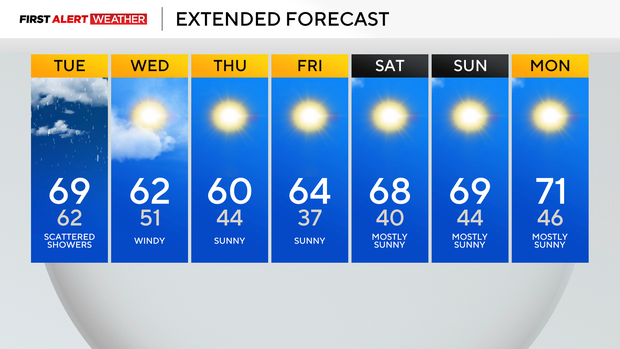
Tuesday and Wednesday of next week look to be where we will see our next rain chance, but model data isn't on agreement on it.
I have highs on both days in the mid-70s, but we would likely be cooler than that if the rain chances pan out.
WEATHER LINKS:
Current Conditions | School Closings & Delays | Submit Your Weather Photos