Rain chances could return to the Pittsburgh-area forecast early next week

Rain chances could return to the forecast for the Pittsburgh area next week.
Any alert days ahead? Nope.
Aware: Yesterday was the tenth day in a row with no measurable precipitation, the longest 'dry' stretch of the year so far
It's pretty nice to be able to go all in with nice weather, knowing that the year up until this point has been VERY wet. So far this year, we have seen 42.01" of rain. It's been spread fairly evenly throughout the year with no long gaps in rain. In fact, our current 10-day stretch of no measurable rain is the longest stretch of the year. This means there is little to complain about as we continue to see comfortable weather in place day after day after day. While rain chances will be back at some point next week (model data isn't in agreement just yet on timing), the pleasant, unseasonably warm afternoon temps look to be sticking around through the middle of November. The Climate Prediction Center, a division of NOAA, agrees. They have our region having around a sixty to eighty percent chance of seeing a warmer-than-normal month in November.
Rain hasn't been an issue all year long, with us still being an inch ahead of the monthly 'average' thirty-year pace when it comes to rain for the month. We normally see 2.83" of rain in October, so we have already seen our monthly average, and we likely won't see any more rain through Saturday. A shortwave does approach our area on Friday morning, potentially bringing a rain chance before sunrise, but I have the chance at just isolated.
Most will have to wait until at least November 1st for our next rain chance. I am putting the rain chance on Sunday at 40 percent, along with Monday, with the GFS being aggressive with moisture that is currently located off the West Coast of Mexico.
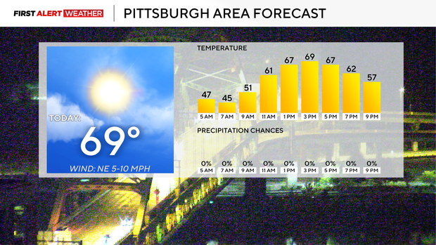
Getting to your forecast, highs today should be back to near 70 degrees. I am going to go 69 degrees for Pittsburgh. Morning lows are in the mid to low 40s, so any frost would be VERY isolated. I keep highs near 70 degrees on both Wednesday and Thursday with morning lows in the mid to upper 40s on those mornings. There is a short wave trough that kicks through early Friday morning. I am keeping a small isolated rain chance on Friday morning in place as the shortwave moves by.
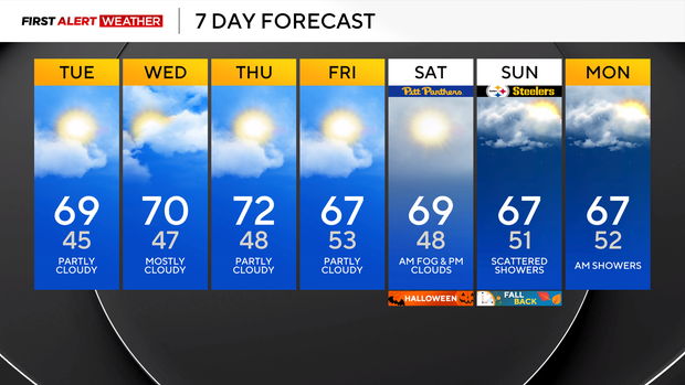
Halloween is looking dry and pleasant. I have Halloween highs near 70 with partly cloudy to mostly cloudy skies. Trick-or-treat hour temperatures will be in the mid to low 60s.


