Pleasant weather will be returning to the Pittsburgh area this afternoon

Pleasant weather will be returning to the Pittsburgh area this afternoon.
Any Alert Days Ahead? Nope
Aware: We've only seen 1.23" of rain so far this month. That is less than half of the 2.64" of rain we 'normally' would have seen through this point of the month. The lack of precipitation means we will see another elevated fire risk today.
We saw the coldest morning of the week this morning with temperatures almost everywhere dipping to the 20s. Highs today will be back in the upper 50s though after we only hit 47° on Wednesday.
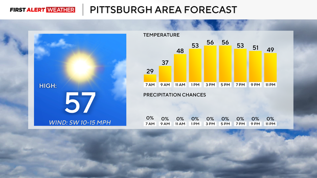
Today is looking dry with noon temperatures in the low 50s. Winds will be out of the west at around 5-10mph.
Rain chances are expected to return to the area on Friday with isolated morning showers and everyone seeing rain early on Friday afternoon. Friday highs will be in the mid to upper 60s depending on rain timing.
The pleasant surprise right now is rain chances dipping for both Saturday and Sunday. There still will be some rain around but at least this morning model data is showing Saturday dry with scattered rain showers on Sunday. I will continue with at least an isolated Saturday rain chance and scattered showers on Sunday.
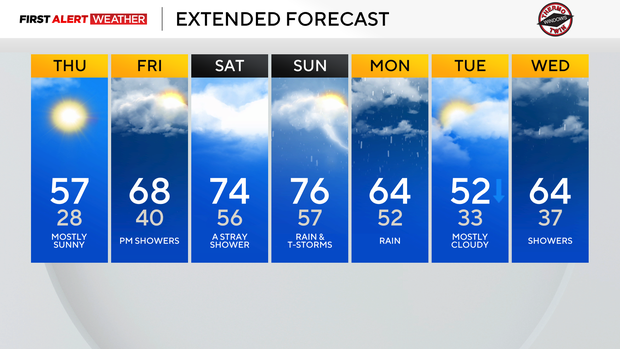
Highs on both days will be in the 70s. Enjoy!
This month has been an interesting one
Normally when you see a March where temperatures are running well above average you can assume strong storms probably led to above-average rain. That has not been the case this month. So far this month we are running 6.7° above average with our temperatures, but precipitation totals are lagging way behind where we normally would be. Through the 26th, the Pittsburgh airport has recorded just 1.23" of rain. That's around 45 percent off of the normal pace that would fine us around 2.64" of rain.
While it may not be something you have noticed yet, there are some real-world consequences including a higher wildfire risk. Parts of our area are still listed as 'abnormally dry' by the U.S. Drought Monitor. Often we can 'bank' March excess rain to help get us through brief dry spells through the rest of the year. That is not going to be the case this year. The good news is that over the next two to three weeks, our weather pattern is conducive to 'above average' rain to fall. Longer range data points to a weather pattern where we should be near normal for precipitation for April overall and also the next three months.
WEATHER LINKS:
Current Conditions | School Closings & Delays | Submit Your Weather Photos