Dry weather sticks around for the Pittsburgh area today before storm chances return tomorrow
Dry weather will be sticking around today in the Pittsburgh area before storm chances return to the forecast tomorrow.
Any Alert Days Ahead? Wednesday is a First Alert Weather Day due to severe risk. Potential for a First Alert Weather Day on Sunday into Monday due to storms, rain, and snow.
Aware: We are already being included in the Storm Prediction Center outlook for storms on Wednesday. While there are questions about the exact setup, the risk of storms is high enough to issue a First Alert Weather Day.
High temperatures today are expected to be near 70 degrees for most places in the area.
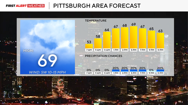
We will see more clouds in place this afternoon after seeing the sun rising this morning. I can't rule out some drizzle this afternoon.
Morning temperatures are in the 50s and 60s with noon temperatures in the mid-60s. Winds will be out of the southeast at around 10mph.
Wednesday could bring strong storms and severe weather to the Pittsburgh area
Wednesday is a First Alert Weather Day due to strong storms expected to roll through mainly in the afternoon. At this point, model data shows three 'waves' of storms that come through, with each progressive wave stronger than the last. The first wave could arrive as soon as 5 a.m. While each wave could see severe storms, it's really the final wave that has us most concerned. It looks like that round of rain and storms arrives around 8 p.m.
Let's start with the first round of rain and storms that's expected to roll through around 5 a.m. on Wednesday. These individual cells will roll through quickly and won't stay for long. Strong wind speeds will certainly be possible, and while low, a severe thunderstorm can't be ruled out with the initial line.
Data indicated the second round of storms rolling through during the early afternoon hours. This time, storms will be a little more developed, and a line of storms developing and rolling along this line will certainly be possible. The risk of severe weather will certainly be there with these storms as they slide by. Frequent lightning and gusty winds should be expected as the line quickly moves from west to east. Multiple severe thunderstorm warnings will be possible as this line passes through.
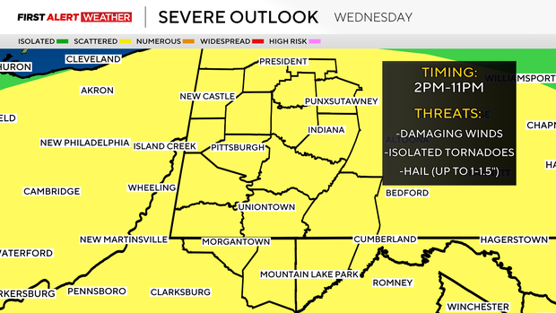
The peak storm chance will come with the final storm chance that occurs around 8 p.m. The intensity of this final round of storms will depend on what happens after the second round of storms. Thunderstorms depend on instability that fuels their intensity. This 'potential energy' is gained through surface heating. The greater the difference between temperatures at the surface and temperatures above the surface, the higher the likelihood of severe weather happening. So if we see sunny weather and we maximize the difference in temperatures at the surface from above the surface (lapse rates), then our chances for large hail and tornadoes would go up.
What will the rest of the week be like?
Behind the storms, temperatures will snap back to near average for this time of the year.
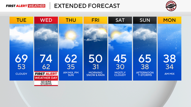
I have a couple of snow chances mixed in with rain chances through the weekend and early next week, with the cooler temperatures bringing the snow chance.