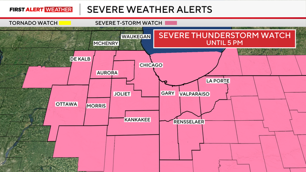
Chicago area under severe thunderstorm watch on Tuesday

Severe thunderstorms moved into the Chicago area on Tuesday morning.
Some areas were seeing strong to severe storms as of around 9:30 a.m. The main threats will be large hail and damaging wind gusts, especially late afternoon into the evening as the front passes through.
A ground stop was issued at Midway Airport until 11:30 a.m. due to thunderstorms. An earlier ground stop at O'Hare Airport has since expired.
A severe thunderstorm watch is in effect through 5 p.m. for La Salle, Kankakee, Kane, Grundy, Will, Cook, DuPage and Kendall counties in Illinois. The Indiana counties under the watch include Lake, Porter, Jasper, La Porte and Newton.
A flood advisory is in effect until 1:30 p.m. for Cook and Will counties in Illinois and Lake County in Indiana.
Golfball-sized hail was spotted in Joliet around 9:30 a.m.
There is a low tornado risk.
Conditions will be warm and humid with highs in the upper 70s and 80s before a cold front moves into the area.
Showers and storms will gradually move south Tuesday night as a front clears the region, bringing a noticeable cooldown into the 30s and 40s by Wednesday morning.