Severe thunderstorm watch issued for Pittsburgh area's southern counties until 8 p.m. Wednesday
The southern part of the Pittsburgh area is under a severe thunderstorm watch until 8 p.m. on Wednesday.
The watch covers Fayette, Greene and Washington counties as well as parts of Indiana, Kentucky, Ohio, Virginia and West Virginia.
What time will storms arrive in Pittsburgh area?
The highest coverage of storms will move in after 5 p.m. and last through late Wednesday evening into the early overnight hours.
There's an isolated severe threat with wind and hail being the main risks, mostly in northern West Virginia from 3 p.m. to 11 p.m. Some low level spin and strong buoyancy near the front may result in an isolated brief and weak tornado.
Storms will congeal into a cluster and line after 8 p.m. with lingering showers through 5 a.m. to 6 a.m. Thursday.
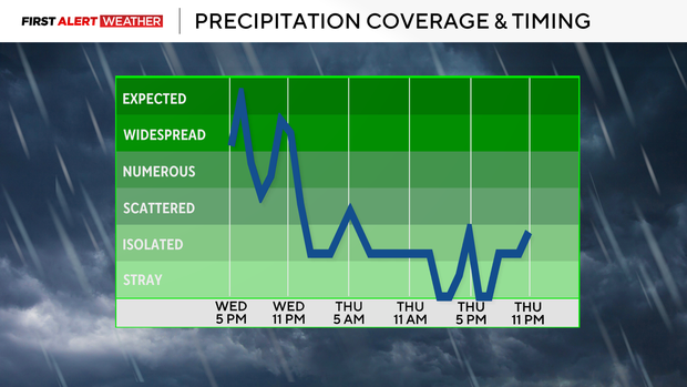
The stalled front will lift back north as a warm front through the day on Thursday. This will lead to temperatures rising well into the mid 70s to low 80s. There won't be much lift, but an isolated to widely scattered shower or storm is possible during the evening to overnight hours. The environment will be supportive of any robust updraft turning strong or severe.
For Friday, lingering showers and storms are possible during the morning to early afternoon hours, but it will still be warm with all of the Pittsburgh area in broad southwest flow at the surface.