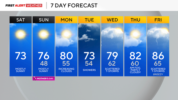
The dry and comfortable weather in Pittsburgh continues through the weekend before rain returns

Cool conditions have settled into the Upper Ohio Valley this weekend as high pressure settles in behind a frontal passage. While temperatures are cool and winds are light enough in spots to support patchy frost, that should quickly become a distant memory as a light westerly, warm and dry wind is expected for Saturday afternoon and evening with ample sunshine.
WEATHER LINKS:
Current Conditions | School Closings & Delays | Submit Your Weather Photos
This should allow afternoon temperatures to max out in the low to mid-70s.
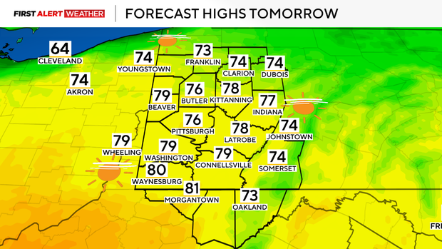
Overnight into Sunday morning, a weak frontal boundary will approach from the northwest. This will really act more like a wind shift boundary and ultimately reinforce the dry, comfortable weather for Sunday. After morning lows in the mid to upper 40s, highs should reach the mid to upper 70s for most spots in the afternoon and evening.
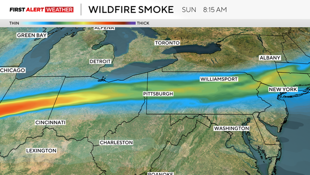
We will be watching for a band of wildfire smoke to move across Western PA between 6 a.m. and 11 a.m. Sunday. This smoke shouldn't lead to major air quality concerns, but it is attributed to the first wildfires of the season that have erupted in Saskatchewan and Manitoba, Canada.
By Monday, our whole weather pattern will begin to shift as attention turns to an approaching upper low that is currently over the Gulf Coast states. That system will move north, leading to an increase in clouds Monday afternoon and evening, followed by showers Monday night and Tuesday.
Since the atmosphere will be very saturated on Tuesday, we expect quite a bit of cloud cover and slow temperature decrease with height, which should limit the instability for thunderstorms. On Wednesday afternoon and evening, we may see a few more storms as temperatures aloft cool a bit along with the intrusion of some drier air.
However, severe weather is not a concern.
On the backside of this system, conditions look rather pristine for some areas of dense fog on Thursday morning due to saturated low levels and very light winds. This should give way to partly cloudy skies and warmer conditions on Thursday as a short-lived ridge settles in.
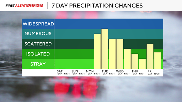
Our next weather system of interest will move in by next Friday, into Saturday. A surge of very warm, moist, and potentially unstable air will overspread our region. This, coupled with some stronger winds aloft, could set up the potential for some severe storms.
We are still a week out, so some minor adjustments are possible, but there is a fairly strong signal in the model guidance already that we will be moving into a more active pattern.
Stay up to date with the KDKA Mobile App – which you can download here!