Mixed clouds and sun this weekend ahead of milder weather next week

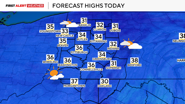
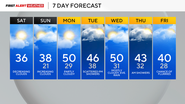
A pesky band of low clouds remains persistent early Saturday morning across Western Pennsylvania. Most of this is attributed to weak upslope flow as a light westerly wind with some remnant moisture banks up against the foothills of the Laurel Highlands and Appalachians. These clouds should gradually break up through the day leaving us with partly to mostly sunny conditions. Temperatures will be a few degrees below average for this time of year with highs generally in the mid to upper 30s for most.
WEATHER LINKS:
Current Conditions | School Closings & Delays | Submit Your Weather Photos
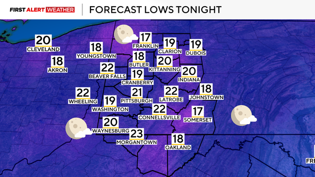
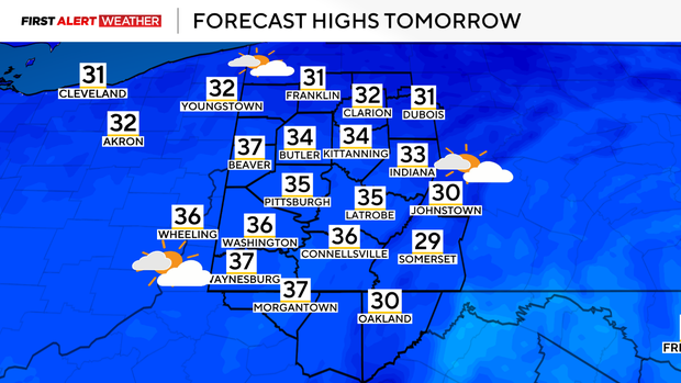
Under mostly clear skies tonight, temperatures will drop into the teens to low 20s. Sunday starts mostly sunny, then a fast-moving disturbance will lead to mostly cloudy skies in the afternoon, although temperatures will still reach the upper 30s thanks to southwesterly winds and warm air from the southwest sliding into the region. This warm air transport will continue on Monday with conditions continuing to trend drier than what model guidance projected earlier in the week. Partly cloudy skies are expected, and southwest winds will push daily max temperatures into the mid 40s and low 50s, which should allow for some decent melting of our temporary snowpack.
A disturbance and its associated cold front will pass through on Tuesday with increased clouds, and a chance of showers with possibly a few snowflakes to mix in, especially north of Pittsburgh as the atmosphere cools aloft. Accumulation looks fairly minimal at the moment and primarily limited to our northernmost counties. Temperatures will be cooler with upper 30s and low to mid 40s for high temperatures expected. Overnight Tuesday into Wednesday, high pressure will quickly pass over the Ohio Valley and Lower Great Lakes leading to some partial clearing, but temperatures will still remain mild. Clouds will quickly increase Wednesday afternoon and evening.
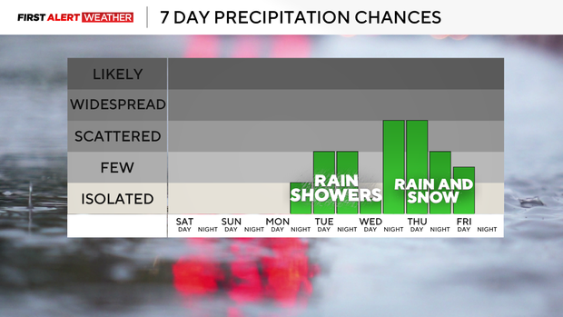
Long range models indicate a stronger trough of low pressure to move in from the northwest by next Wednesday night into Thursday. This will carry a stronger cold front along with rain and possibly some snow.
Stay up to date with the KDKA Mobile App – which you can download here!