Brief cooldown this weekend ahead for the Pittsburgh area with potential storms next week
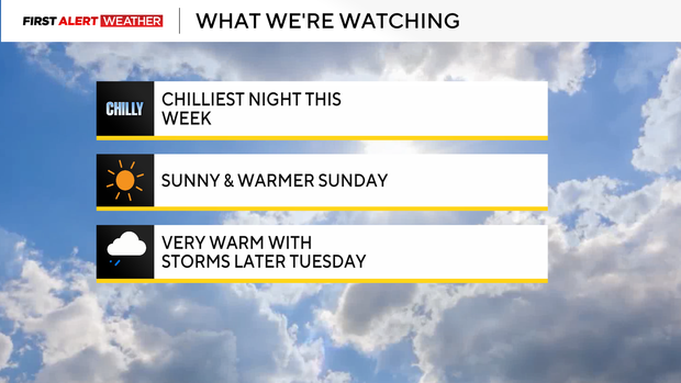
What a difference a day makes! Friday's high of 76 in Pittsburgh gives way to current temperatures in the 40s and 50s, with lows tonight hovering near the upper 30s (below normal for this time of year).
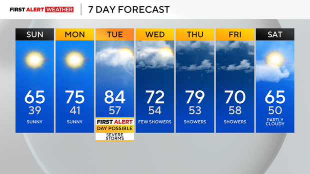
First Alert: Possible Tuesday Afternoon-Night (Severe Storms)
Climate: Average High: 67 | Average Low: 45
April Precipitation: 3.23" (+0.45")
The strong cold front swept through and brought an end to the rain, but left us with falling temps and windy conditions that will continue through the evening. Winds will gradually die down a bit overnight, but should stay elevated enough along with a bit of cloud cover to prevent any widespread worries about frost.
Skies will clear overnight under high pressure as high pressure settles in on Sunday morning, bringing a return to sunny skies and pleasant highs by afternoon in the mid-60s.
Much warmer air returns Monday with highs in the 70s, and Tuesday will bring a run into the 80s before another cold front stirs up the chance for strong to severe storms later Tuesday afternoon and evening. The timing and setup are not definite right now, so we're watching for the potential of a First Alert Weather day on Tuesday and will update as we get closer. That cold front will stall out to the south of us on Wednesday before it lifts back to the north on Thursday as a warm front. This will carry another chance of rain and storms toward the end of next week.