Heavy rain through at least Saturday evening, flood watch through Saturday afternoon
Flood watch through Saturday afternoon. Weather Alert Next Monday and Tuesday for heat. Bill Kelly has the forecast.
Watch CBS News
Flood watch through Saturday afternoon. Weather Alert Next Monday and Tuesday for heat. Bill Kelly has the forecast.

For the first time in nine days, Friday will bring below-normal temperatures with highs in the mid or low 80s under mostly cloudy skies in the Philadelphia region. Along with the cloud cover will be scattered showers and storms throughout the day, bringing occasional rounds of heavy rain through at least Saturday evening. Bill Kelly reports.

Some rain is filtering in Friday morning and we should expect light to moderate downpours throughout the day, Andrew Kozak reports.

Bill Kelly says storms will bring heavy downpours in the Philadelphia region on Friday.

Bill Kelly has the latest weather forecast for the Philadelphia region.

The decreased humidity in the Philadelphia region on Thursday will feel like relief after the sweltering days we've had. There are some rumbles of thunder and chances of rain in the area that pick up tonight, Andrew Kozak reports.

Bill Kelly says the heat wave in Philadelphia will continue on Thursday, but it will be less humid.

Bill Kelly has the latest weather forecast for the Philadelphia region in the midst of another heat wave.

An excessive heat warning remains in effect for Philadelphia and much of the surrounding suburbs Wednesday as feels-like temps approach 110 degrees. Overnight, we're tracking a marginal risk for severe weather and thunderstorms that could produce heavy downpours. Meteorologist Tammie Souza has the latest forecast.

An excessive heat warning is in effect Wednesday for Philadelphia and the surrounding suburbs, where feels-like temps could reach between 106-108 degrees. Southeastern Pennsylvania is also under a marginal risk for severe weather, or level 1 of 5, for Wednesday night. Meteorologist Kate Bilo has your forecast.

Tammie Souza says severe weather on Wednesday could bring the Philadelphia region strong winds, flash flooding and a chance of isolated tornadoes.

Tammie Souza has the latest weather forecast for the Philadelphia area as the heatwave continues.
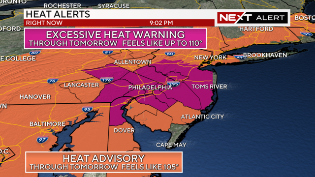
Tuesday will be the sixth day of the ongoing heat wave in the Delaware Valley. Highs will reach the mid-90s but the heat index will get up to 105 degrees.

The heat and humidity continue in Philadelphia and the Delaware Valley Tuesday as the heat index (aka feels like temps) soars to 105 degrees. A heat advisory remains in effect until Wednesday evening, and according to CBS News Philadelphia meteorologist Kate Bilo, more 90-degree days are in the forecast this week.

Get ready to sweat, says Meteorologist Tammie Souza. Above-average temperatures in the Philadelphia region will continue through most of the week.

Tammie Souza has the latest weather forecast for the Philadelphia region as we deal with scorching temperatures.

A heat advisory goes into effect Monday morning as feels-like temps climb toward 102 degrees. Tomorrow, temperatures will feel even higher, closer to 105. Hurricane Beryl made landfall in east Texas as a Category 1 storm early Monday, and we're tracking moisture from that storm as it makes its way toward the east coast. Meteorologist Kate Bilo has your forecast.

The heat isn't going anywhere. Andrew Kozak says the Philadelphia region will be in a heat advisory on Monday through Tuesday as we continue to deal with brutal conditions.

Andrew Kozak has the latest forecast for the Philadelphia region as we end the Fourth of July holiday weekend.
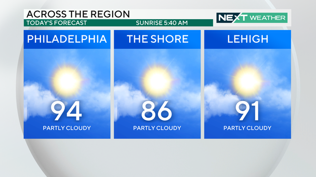
Sunday starts muggy with a slightly less humid afternoon in store. Then the week starts off hot and humid, and the remnants of Beryl could bring several days of rain to the region.

Sunday will still be warm with temperatures in the upper 90s, but it'll feel slightly less humid. The heat and humidity ramp back up on Monday, and remnants from Tropical Storm Beryl could bring some heavy rain to the region later in the week. Meteorologist Tammie Souza has your forecast.

Unsettled weather will likely stay through at least the start of next weekend. Andrew Kozak has the forecast.

Saturday's dangerous hot weather around the Philadelphia region has triggered an Excessive Heat Warning, which is the highest level of heat alert for all areas adjacent to the I-95 corridor and eastward. Meteorologist Andrew Kozak has your evening forecast for the Philadelphia area and the latest on Tropical Storm Beryl.

Hot weather is back once again in Philadelphia, the Pa. suburbs, South Jersey and Delaware, with feels-like temps in the triple digits in the cards across much of the region, and storm chances both weekend days, Tammie Souza reports.

High temperature across the region will peak between 90-95° , with feels-like temps over 100°. The hottest time of the day will be between 4pm-7pm. Bill Kelly has the forecast