Flash flood warning in effect for parts of Philadelphia region Sunday night as heavy rain moves through


A NEXT Weather Alert is in effect on Sunday night as multiple counties in the Philadelphia region are under a flash flood warning due to heavy rain.
The flash flood warnings are in effect in Burlington and Camden counties in New Jersey, and Bucks, Montgomery and Philadelphia counties in Pennsylvania until 12 a.m.
In some areas, roughly two to three inches of rain has fallen in just under two hours.
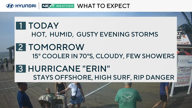
Behind these storms, much cooler air arrives, and we begin the week with highs only in the mid-70s. It will be cloudy with scattered showers on Monday and Tuesday. By Wednesday, some sun returns with isolated thunderstorms and highs near 80.
Hurricane Erin update
After a rapid intensification to a Category 5 storm with 160 mph winds Saturday night, Hurricane Erin has weakened to a Category 3 storm with 125 mph winds, which is still considered major.
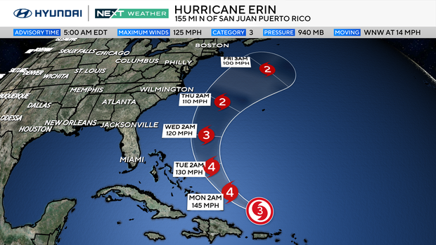
It is moving WNW at 14 mph and expected to become larger and more organized as it re-strengthens to a Category 4 storm. The forecast track remains north of Puerto Rico and east of the Bahamas, although high surf, some storm surge, and dangerous rip currents are possible along those shorelines.
Erin turns to the north in the next few days, passing between our east coast and Bermuda. As it travels northward off the Jersey shore on Wednesday and Thursday, high surf and dangerous rip currents are likely.
Here's your 7-day forecast:
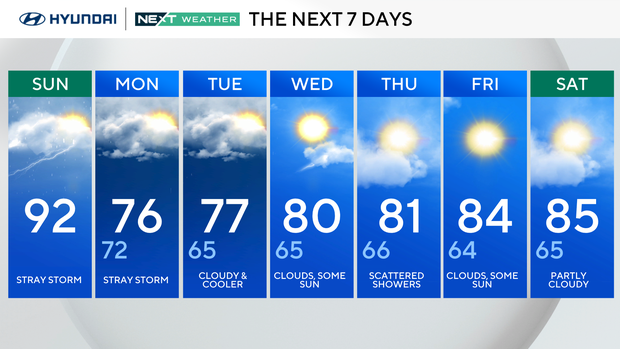
Sunday: Stray storm. High 92, Low 72
Monday: Stray storm. High 76, Low 72
Tuesday: Cloudy and cooler. High 77, Low 65
Wednesday: Clouds, some sun. High 80, Low 65
Thursday: Scattered showers. High 81, Low 66
Friday: Clouds, some sun. High 84, Low 64
Saturday: Partly cloudy. High 85, Low 65


