Severe storms bring heavy rain, damaging winds to Philadelphia region Wednesday. Here's the forecast.


A NEXT Weather Alert Day continues for the Philadelphia area, as rain and wind continue to cause problems on the roads and in the skies.
The impacts of this storm across Pennsylvania, New Jersey and Delaware include ponding or minor flooding on roads, downed branches and power outages, which we have seen throughout the area this afternoon.
A groundstop at Philadelphia International Airport has been lifted, but the FAA says passengers should expect weather-related delays.
A tree came down onto power lines at 13th and Wharton streets in Philadelphia, causing scattered power outages in the neighborhood. PECO says that across the area, there are more than 6,800 customers without power.
Here's what you need to know today.
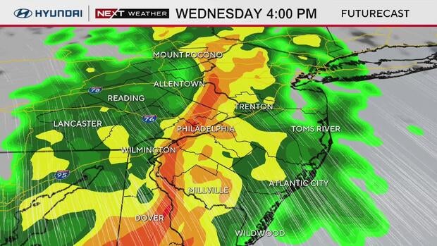
When storms arrive in Philadelphia today
Rain and storms are moving through the city of Philadelphia as of 4 p.m., with pockets of heavy downpours.
The storms should start to taper off around 7 p.m. in Philadelphia.
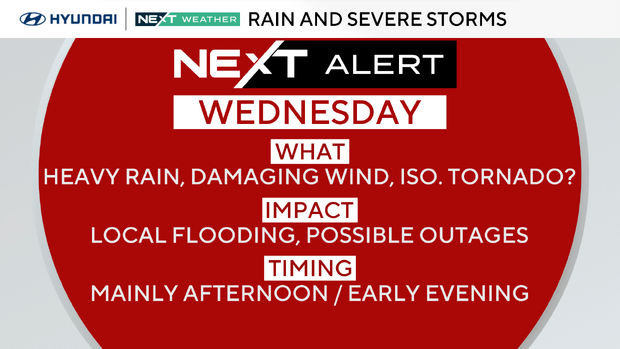
Delaware and parts of South Jersey and Pennsylvania are at a slight (level 2) risk for severe weather today, while the rest of our region is at a marginal (level 1) risk.
What threats are the storms bringing?
The biggest threat with any severe storm locally will be damaging straight-line winds, although we cannot rule out the potential for an isolated tornado.
This line of storms could also bring heavy rainfall, with as much as three-quarters of an inch to 1.5 inches falling over the course of just a few hours.
A severe thunderstorm warning has been issued for Sussex County and southeastern Kent County in Delaware until 5:30 p.m. ET, according to the National Weather Service.
While the region does need a good soaking rain, this much in such a short time is less than ideal. This may lead to possible ponding and road spray during tonight's evening commute.
Philadelphia weather forecast for rest of the week
Behind the storm on Thursday, it's seasonably chilly with a gusty wind that will make it feel much colder. On Friday, we will hover near 50 with sunshine and less wind.
Rain showers are once again possible Saturday night, and there is even a chance for a snow shower as colder air moves in.
Don't forget, daylight saving time begins Sunday morning, so flip the clocks ahead one hour Saturday night and change the batteries in your smoke and carbon monoxide detectors.
Here's the 7-day forecast:
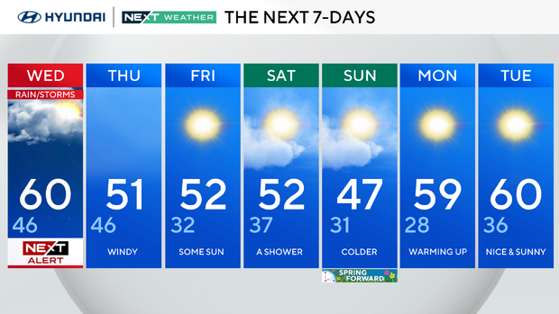
Wednesday: NEXT Weather Alert for rainstorms. High 60, low 46.
Thursday: Windy. High 51, low 47.
Friday: Some sun. High 51, low 32.
Saturday: A shower. High 52, low 37.
Sunday: Colder. High 47, low 31.
Monday: Warming up. High 59, low 28.
Tuesday: Nice and sunny. High 60, low 36.
Get the latest weather info on the CBS News Philadelphia app.


