Possible snow, rain in Philadelphia region could create messy evening travel. Here's the weather forecast.

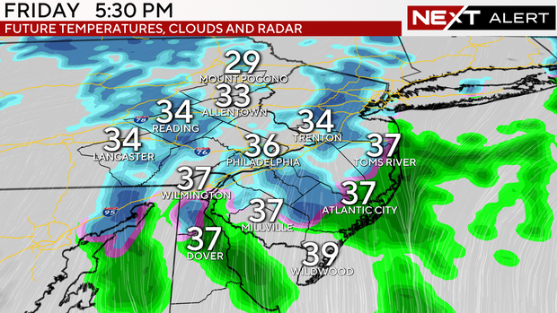
As temperatures drop closer to freezing by Friday evening, there may be a transition from rain to snow showers as the remnants of a clipper system approach the region. Clipper systems are typically moisture-starved and not big snow producers, but this one will phase with a newly formed coastal low, creating enhanced lift and scattered bursts of snow through midnight.
Currently, the outlook is a coating to an inch along either side of the I-95 corridor. Farther north and west, there could be over an inch stretching from upper Montgomery, upper Chester and upper Bucks counties through the Lehigh Valley and Berks counties.
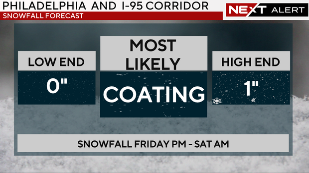
The Poconos will be coldest all day, and 2 to 4 inches of snow are possible. These forecast totals may shift up or down a bit, depending on the temperatures.
Any snow or rain will slow the evening commute, and there may be some travel delays at the airport for evening flights.
Weekend weather forecast for last-minute holiday shopping
The storm will depart early Saturday morning, and skies will clear quickly to sunshine as very dry and bitterly cold air arrives. Saturday's highs will hover near freezing, with wind chills in the teens and 20s. As northwest winds increase by the afternoon, lake-effect snow bands may form and reach as far east as the Poconos and Lehigh Valley.
By the way, winter officially begins Saturday morning. Saturday will be the shortest day of the year, known as the winter solstice. Just how much sunlight will the region get? Just a measly 9 hours, 19 minutes and 59 seconds.
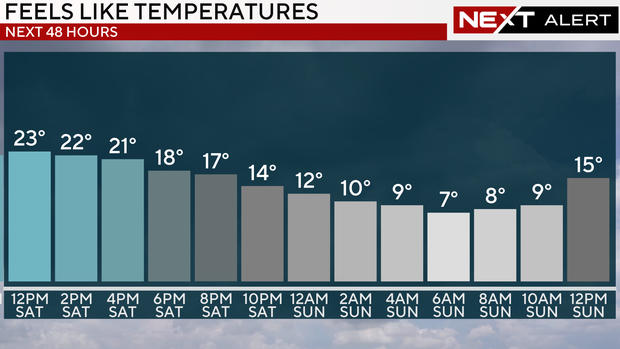
By Sunday morning, temperatures will drop to the teens. Despite bright sunshine, they will only rebound to the mid-to late-20s by afternoon. This will be the coldest day of the season so far.
What's the weather for Christmas, Hanukkah and Kwanzaa?
On Monday morning, you will need extra layers and extra time to warm up the car as temperatures range from 8 to 13 degrees.
Highs will hover near freezing under sunny skies.
Please provide your pets with a warm and dry place, preferably indoors. They are not used to the frigid Arctic air any more than we are.
On Tuesday, Christmas Eve, the skies will be cloudy, and scattered rain showers are possible. Highs will be closer to normal, in the low 40s.
On Wednesday, Christmas Day, highs will be in the low to mid-40s, with partly cloudy skies and a lingering shower. Hanukkah begins Wednesday night, and there may be a few scattered showers.
Thursday is Kwanzaa, and it will be partly to mostly cloudy with a chance of scattered showers and highs in the low 40s.
The NEXT 7-day weather forecast
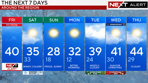
Friday: NEXT Weather Alert. High 40
Saturday: Windy, colder. High 35, Low 33
Sunday: Frigid, sunny. High 28, Low 18.
Monday: Bitter morning. High 32, Low 12.
Tuesday: Mostly cloudy. High 39, Low 24.
Wednesday: Sun for Christmas. High 41, Low 30.
Thursday: Cloudy. High 44, Low 29.


