Sunny, nice and breezy Tuesday in Philadelphia region. Here's the weather forecast.

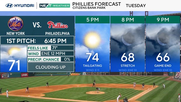
High pressure remains in control for most of today in the Philadelphia region, keeping skies mostly sunny. Today's highs will be in the low to mid 70s, with a light northeast breeze and increasing clouds along the coast by afternoon.
It'll be dry and pleasant for the Phillies game, but you may notice more cloud cover.
We'll see those clouds tonight as a coastal low develops offshore and lifts north. This system should stay east of us, but it should throw a few scattered showers our way, mainly closer to the Jersey Shore and Delaware beaches, with the slight chance of a thunderstorm.
Wednesday is a dreary, rainy day for those of you at the Shore, and showers may drift farther inland into Philadelphia.
Winds turn breezier out of the northeast, especially near the coast, with gusts up to 25–30 mph. Highs on Wednesday hold in the upper 60s to low 70s, keeping the cool feel going.
Conditions improve again Thursday into the weekend as the low departs. Skies turn sunnier and temperatures rebound into the mid and upper 70s by Thursday afternoon.
A weak cold front slides through late Thursday, but it looks dry.
From Friday into the weekend, high pressure builds back in, bringing a stretch of dry, seasonable weather with comfortable highs in the 70s and low humidity.
Here's your 7-day forecast:

Tuesday: Sunny. High 76, Low 55.
Wednesday: Clouds, showers. High 71, Low 61.
Thursday: Warmer, sunny. High 82, Low 61.
Friday: Mostly sunny. High 82, Low 61.
Saturday: Mostly sunny. High 81, Low 61.
Sunday: Mostly sunny. High 82, Low 61.
Monday: Mostly sunny. High 81, Low 62.