A sunny, spring-like Saturday turns to wintry cold in just one afternoon. Here's the forecast.

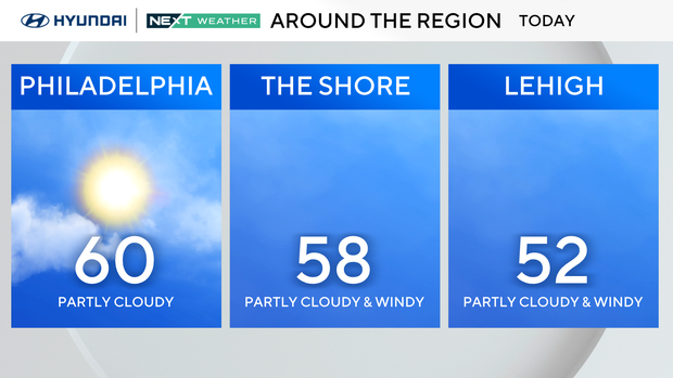
This is the time of year we affectionately call "Sprinter". It's a combo of spring and winter and our weekend will be very sprinter-like with highs near 60 today and then plummeting to the 30s this evening and 20s tomorrow morning.
That's a 40-degree drop in less than 24 hours!
Planning to leave the house around noon today and returning later this evening? Make sure to take the winter coat with you.
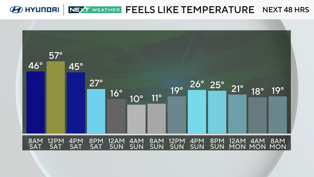
If that's not enough, the wind chills Sunday morning will feel like single digits and actual afternoon highs will only reach the mid-30's.
So why will there be a temperature freefall?
A clipper system is passing by to our north today leaving us with clouds and some afternoon sun. There could even be a rain shower for all of you in the Lehigh Valley and Poconos. This afternoon a push of Arctic air arrives on the backside of the clipper and our temperatures will tumble quickly and winds will increase with gusts to 40 mph.
Red Flag warning and high fire risk in Philadelphia region
Gusty winds and low humidity could enhance the spread of any fires that break out Saturday, the National Weather Service warned.
A Red Flag Warning is in effect across the entire state of Delaware as well most of the state of Maryland and eastern and central Virginia. Outdoor burning is not recommended during these conditions.
The alert expires at 8 p.m.
Across Philadelphia and the suburban counties in Pennsylvania, as well as all of South and Central New Jersey, there is a special weather statement in effect for high fire risk. While not as severe as a red flag warning, conditions are similar in these areas -- winds and dry air could spread any fires that break out.
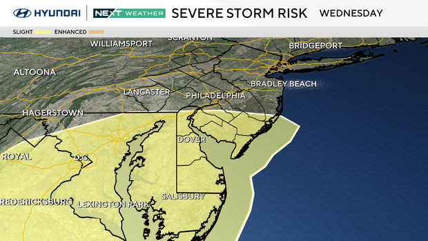
Chance of severe weather in parts of Philadelphia area: the week ahead
Bright sunshine returns on Monday, but the warmth will lag behind. Morning lows will be in the 20s and afternoon highs near 40.
By Tuesday we are on the rebound to the mid-50s with increasing clouds ahead of a vigorous spring storm system. A few showers are possible late Tuesday night as a warm front lifts northward.
Wednesday is a NEXT Weather Alert Day for the possibility of severe storms. Gusty southwest winds will push our temperatures to the mid-60's and By evening a strong cold front will bring strong to severe storms.
The Day 5 outlook from the Severe Weather Prediction Center includes a chance of severe storms over a large part of the east coast including our region. It is too early to determine any severity levels, but this is a good time to dust off your severe weather plan and have the family prepared as we head into spring.
Behind the storm on Thursday, we are 15 degrees colder, in the upper 40s with partly sunny skies.
Friday, we hover near 50 with partly sunny skies.
- Daylight Saving Time begins next Sunday morning, so flip the clocks ahead 1 hour next Saturday night and don't forget to change the batteries in your smoke and carbon monoxide detectors.
Here's the 7-day forecast:
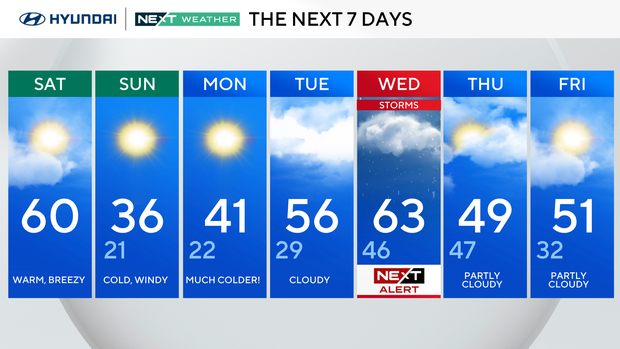
Saturday: Warm, windy. High 58, low 42.
Sunday: Much colder! High 36, low 21.
Monday: Sunny, chilly. High 41, low 22.
Tuesday: Clouding up. High 54, low 29.
Wednesday: NEXT Weather Alert for storms. High 63, low 47.
Thursday: Clearing. High 46, low 44.
Friday: Mostly sunny. High 51, low 32.
Get the latest weather info on the CBS News Philadelphia app.